|
|
|
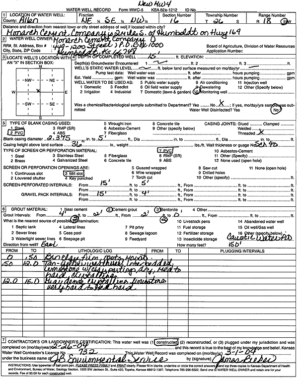
Specific Water Well Detail |
|
|
| Location Info | |||
| Owner: Monarch Cement Company | Status: Constructed | ||
| Location: T26S, R18E, Sec. 16, NE SE NW | County: Allen | ||
| Directions: from Humboldt: 2 mi S on Hwy 169 - Monarch Cement Company | |||
| Latitude: 37.7865113 | Longitude: -95.4439086 | Datum NAD 27 | |
| Latitude: 37.7865529 | Longitude: -95.4441683 | Datum NAD 83 | |
| Longitude and latitude calculated by Survey from township-range-section-quarter calls. Only good to within the quarter call accuracy. | |||
| View well on interactive map | |||
| General Info | ||
| Well Depth: 15 ft. | Elevation: ft. | |
| Static Water Level: ft. | Est. Yield: gpm. | |
| Comp. Date: 26-Feb-2004 | Well Use: Monitoring well/observation/piezometer | |
| DWR Applic. #: | Other ID: MW 4 | |
| Driller Info | ||
| Driller: JB Environmental Service and Supply | License #: 732 | |
| Scanned Form | View scan |
|
Chemical Sample Submitted?:
Water Well disinfected?: | ||
| Casing Info | ||
| Casing Type:
Casing Joints: |
Diam: in. to ft | |
| Casing height above land surface: in
Casing Weight: lbs/ft Wall thickness or gauge no.: | ||
| Screen and Perforation Info | ||
| Screen Type: | Screen Openings: | |
| Screen-perforated intervals | From: ft to ft | |
| Gravel pack intervals | From: ft to ft | |
| Grout Info | ||
| Grout used: | From: to ft | |
| Source of Possible Contamination | ||
| Source: | ||
| Direction from well: | Distance: ft | |
| Lithologic Log
(Log data entered by KGS.) | ||
| From: 0 ft. to .5 ft. | Brown clay, firm, roots, moist | |
| From: .5 ft. to 12 ft. | Tan-yellow weathered, interbedded, limestone with clay partings, dry, medium to hard, crystalline | |
| From: 12 ft. to 15 ft. | Gray dense crystalline limestone, very hard to medium hard | |