|
|
|
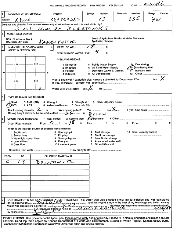
Specific Water Well Detail |
|
|
| Location Info | |||
| Owner: Kahan and Associates | Status: Plugged | ||
| Location: T23S, R4W, Sec. 13, SE SE SE | County: Reno | ||
| Directions: from Burrton: 3 mi NW | |||
| Latitude: 38.0439986 | Longitude: -97.7027395 | Datum NAD 27 | |
| Latitude: 38.0440097 | Longitude: -97.7030636 | Datum NAD 83 | |
| Longitude and latitude calculated by Survey from township-range-section-quarter calls. Only good to within the quarter call accuracy. | |||
| View well on interactive map | |||
| General Info | ||
| Well Depth: 18 ft. | Elevation: ft. | |
| Static Water Level: 9 ft. | Est. Yield: gpm. | |
| Comp. Date: 26-Feb-2004 | Well Use: Monitoring well/observation/piezometer | |
| DWR Applic. #: | Other ID: MW 6 | |
| Driller Info | ||
| Driller: Miller Drilling | License #: 447 | |
| Scanned Form | View scan |
| Casing Info | ||
|
Casing Type:
Diam: in. Casing height above land surface: in | ||
| Grout Info | ||
| Grout used: | From: to ft | |
| Source of Possible Contamination | ||
| Source: | ||
| Direction from well: | Distance: ft | |