|
|
|
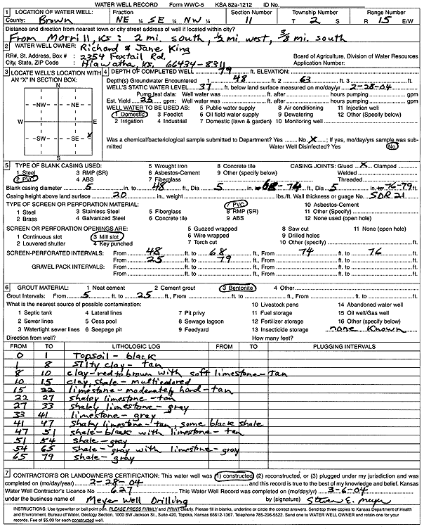
Specific Water Well Detail |
|
|
| Location Info | |||
| Owner: King, Richard and Jane | Status: Constructed | ||
| Location: T2S, R15E, Sec. 11, NE SE NW | County: Brown | ||
| Directions: from Morrill: 2 mi S, .5 mi W, .38 mi S | |||
| Latitude: 39.8946731 | Longitude: -95.7051981 | Datum NAD 27 | |
| Latitude: 39.894674 | Longitude: -95.7054617 | Datum NAD 83 | |
| Longitude and latitude calculated by Survey from township-range-section-quarter calls. Only good to within the quarter call accuracy. | |||
| View well on interactive map | |||
| General Info | ||
| Well Depth: 79 ft. | Elevation: ft. | |
| Static Water Level: 37 ft. | Est. Yield: 25 gpm. | |
| Comp. Date: 28-Feb-2004 | Well Use: Domestic | |
| DWR Applic. #: | Other ID: | |
| Driller Info | ||
| Driller: Meyer Well Drilling | License #: 627 | |
| Scanned Form | View scan |
|
Chemical Sample Submitted?:
Water Well disinfected?: | ||
| Casing Info | ||
| Casing Type:
Casing Joints: |
Diam: in. to ft | |
| Casing height above land surface: in
Casing Weight: lbs/ft Wall thickness or gauge no.: | ||
| Screen and Perforation Info | ||
| Screen Type: | Screen Openings: | |
| Screen-perforated intervals | From: ft to ft | |
| Gravel pack intervals | From: ft to ft | |
| Grout Info | ||
| Grout used: | From: to ft | |
| Source of Possible Contamination | ||
| Source: | ||
| Direction from well: | Distance: ft | |
| Lithologic Log
(Log data entered by KGS.) | ||
| From: 0 ft. to 1 ft. | Topsoil | |
| From: 1 ft. to 8 ft. | Silty clay, tan | |
| From: 8 ft. to 10 ft. | Clay, red to brown with soft tan limestone | |
| From: 10 ft. to 15 ft. | Clay, shale, multicolored | |
| From: 15 ft. to 22 ft. | Limestone, moderately hard, tan | |
| From: 22 ft. to 27 ft. | Shaley limestone, tan | |
| From: 27 ft. to 33 ft. | Shaley limestone, gray | |
| From: 33 ft. to 41 ft. | Limestone, gray | |
| From: 41 ft. to 47 ft. | Shaley limestone, tan; some black shale | |
| From: 47 ft. to 51 ft. | Shale, black, with tan limestone | |
| From: 51 ft. to 54 ft. | Shale, gray | |
| From: 54 ft. to 65 ft. | Shale, gray, with gray limestone | |
| From: 65 ft. to 79 ft. | Shale, gray | |