|
|
|
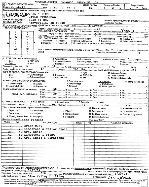
Specific Water Well Detail |
|
|
| Location Info | |||
| Owner: Zutterman, David | Status: Constructed | ||
| Location: T2S, R7E, Sec. 35, NW SW NW | County: Marshall | ||
| Directions: from Hwy 36 and 11 Rd: .25 mi S | |||
| Latitude: 39.8373163 | Longitude: -96.6183538 | Datum NAD 27 | |
| Latitude: 39.8373179 | Longitude: -96.6186507 | Datum NAD 83 | |
| Longitude and latitude calculated by Survey from township-range-section-quarter calls. Only good to within the quarter call accuracy. | |||
| View well on interactive map | |||
| General Info | ||
| Well Depth: 80 ft. | Elevation: ft. | |
| Static Water Level: 48 ft. | Est. Yield: 10 gpm. | |
| Comp. Date: 22-Jan-2004 | Well Use: Domestic, Lawn and Garden | |
| DWR Applic. #: | Other ID: | |
| Driller Info | ||
| Driller: Blue Valley Drilling | License #: 518 | |
| Scanned Form | View scan |
|
Chemical Sample Submitted?:
Water Well disinfected?: | ||
| Casing Info | ||
| Casing Type:
Casing Joints: |
Diam: in. to ft | |
| Casing height above land surface: in
Casing Weight: lbs/ft Wall thickness or gauge no.: | ||
| Screen and Perforation Info | ||
| Screen Type: | Screen Openings: | |
| Screen-perforated intervals | From: ft to ft | |
| Gravel pack intervals | From: ft to ft | |
| Grout Info | ||
| Grout used: | From: to ft | |
| Source of Possible Contamination | ||
| Source: | ||
| Direction from well: | Distance: ft | |
| Lithologic Log
(Log data entered by KGS.) | ||
| From: 0 ft. to 9 ft. | brown clay | |
| From: 9 ft. to 29 ft. | limestone and yellow shale | |
| From: 29 ft. to 42 ft. | gray shale | |
| From: 42 ft. to 54 ft. | limestone and flint | |
| From: 54 ft. to 82 ft. | gray shale and limestone | |