|
|
|
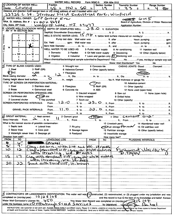
Specific Water Well Detail |
|
|
| Location Info | |||
| Owner: GPP Group, Inc. | Status: Constructed | ||
| Location: T33S, R4E, Sec. 19, SE NW SE | County: Cowley | ||
| Directions: 22725 C St, Strother Field Industrial Park, Winfield | |||
| Latitude: 37.1623545 | Longitude: -97.028434 | Datum NAD 27 | |
| Latitude: 37.162382 | Longitude: -97.0287492 | Datum NAD 83 | |
| Longitude and latitude calculated by Survey from township-range-section-quarter calls. Only good to within the quarter call accuracy. | |||
| View well on interactive map | |||
| General Info | ||
| Well Depth: 23 ft. | Elevation: ft. | |
| Static Water Level: 15.96 ft. | Est. Yield: gpm. | |
| Comp. Date: 23-Oct-2003 | Well Use: Monitoring well/observation/piezometer | |
| DWR Applic. #: | Other ID: GM 5 | |
| Driller Info | ||
| Driller: Deffenbaugh Field Services | License #: 650 | |
| Scanned Form | View scan |
|
Chemical Sample Submitted?:
Water Well disinfected?: | ||
| Casing Info | ||
| Casing Type:
Casing Joints: |
Diam: in. to ft | |
| Casing height above land surface: in
Casing Weight: lbs/ft Wall thickness or gauge no.: | ||
| Screen and Perforation Info | ||
| Screen Type: | Screen Openings: | |
| Screen-perforated intervals | From: ft to ft | |
| Gravel pack intervals | From: ft to ft | |
| Grout Info | ||
| Grout used: | From: to ft | |
| Source of Possible Contamination | ||
| Source: | ||
| Direction from well: | Distance: ft | |
| Lithologic Log
(Log data entered by KGS.) | ||
| From: 0 ft. to .5 ft. | gravel | |
| From: 5 ft. to 7 ft. | clay, dark brown, with silt and black streaks | |
| From: 10 ft. to 12 ft. | clay with abundant silt, grayish white nodules with black streaks | |
| From: 15 ft. to 17 ft. | clay with abundant silt, grayish white nodules with black streaks | |
| From: 20 ft. to 22 ft. | sand with trace silt, light brown | |