|
|
|
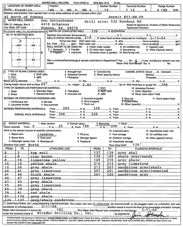
Specific Water Well Detail |
|
|
| Location Info | |||
| Owner: Gottschomer, Don | Status: Constructed | ||
| Location: T15S, R18E, Sec. 19, NW NE NW | County: Franklin | ||
| Directions: 532 Woodsun Rd - from Pomona: 8.5 mi N | |||
| Latitude: 38.7379056 | Longitude: -95.4578686 | Datum NAD 27 | |
| Latitude: 38.7379121 | Longitude: -95.458125 | Datum NAD 83 | |
| Longitude and latitude calculated by Survey from township-range-section-quarter calls. Only good to within the quarter call accuracy. | |||
| View well on interactive map | |||
| General Info | ||
| Well Depth: 320 ft. | Elevation: ft. | |
| Static Water Level: 218 ft. | Est. Yield: 5 gpm. | |
| Comp. Date: 11-Mar-2004 | Well Use: Domestic | |
| DWR Applic. #: | Other ID: | |
| Driller Info | ||
| Driller: Strader Drilling Co., Inc. | License #: 182 | |
| Scanned Form | View scan |
|
Chemical Sample Submitted?:
Water Well disinfected?: | ||
| Casing Info | ||
| Casing Type:
Casing Joints: |
Diam: in. to ft | |
| Casing height above land surface: in
Casing Weight: lbs/ft Wall thickness or gauge no.: | ||
| Screen and Perforation Info | ||
| Screen Type: | Screen Openings: | |
| Screen-perforated intervals | From: ft to ft | |
| Gravel pack intervals | From: ft to ft | |
| Grout Info | ||
| Grout used: | From: to ft | |
| Source of Possible Contamination | ||
| Source: | ||
| Direction from well: | Distance: ft | |
| Lithologic Log
(Log data entered by KGS.) | ||
| From: 0 ft. to 2 ft. | Topsoil | |
| From: 2 ft. to 8 ft. | Clay, brown | |
| From: 8 ft. to 10 ft. | Limestone, yellow | |
| From: 10 ft. to 12 ft. | Shale, yellow | |
| From: 12 ft. to 24 ft. | Shale, gray | |
| From: 24 ft. to 41 ft. | Limestone, gray | |
| From: 41 ft. to 46 ft. | Shale, black | |
| From: 46 ft. to 47 ft. | Limestone, gray | |
| From: 47 ft. to 55 ft. | Shale, gray | |
| From: 55 ft. to 65 ft. | Limestone, gray | |
| From: 65 ft. to 79 ft. | Shale, gray | |
| From: 79 ft. to 81 ft. | Shale, red | |
| From: 81 ft. to 124 ft. | Shale, gray | |
| From: 124 ft. to 137 ft. | Shaley sandstone, gray | |
| From: 137 ft. to 139 ft. | Shale, gray | |
| From: 139 ft. to 149 ft. | Sandy shale, gray | |
| From: 149 ft. to 210 ft. | Shale, gray | |
| From: 210 ft. to 213 ft. | Limestone, gray | |
| From: 213 ft. to 257 ft. | Shaley sandstone, gray | |
| From: 257 ft. to 261 ft. | Cemented sandstone, gray | |
| From: 261 ft. to 320 ft. | Sandstone, gray | |