|
|
|
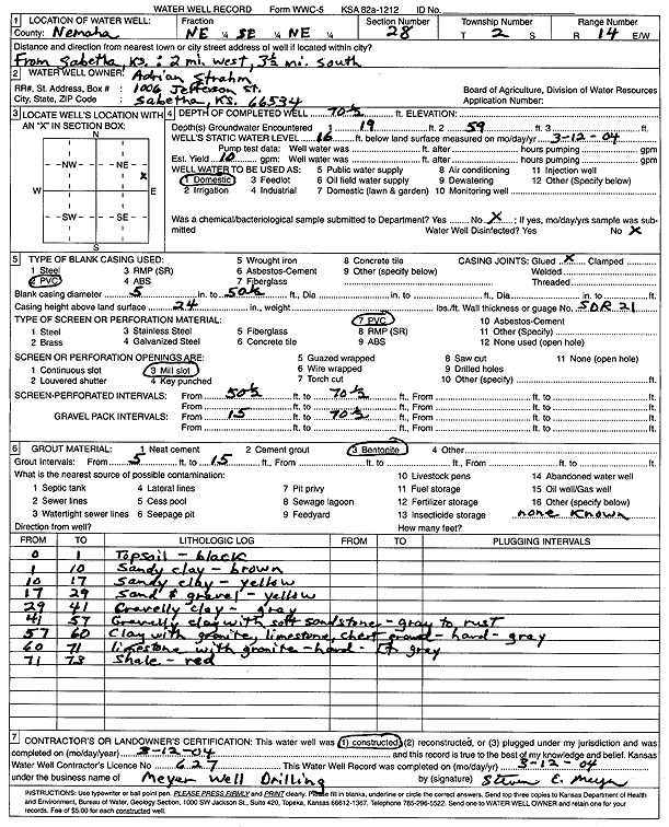
Specific Water Well Detail |
|
|
| Location Info | |||
| Owner: Strahm, Adrian | Status: Constructed | ||
| Location: T2S, R14E, Sec. 28, NE SE NE | County: Nemaha | ||
| Directions: from Sabetha: 2 mi W and 3.5 mi S | |||
| Latitude: 39.8514964 | Longitude: -95.8461267 | Datum NAD 27 | |
| Latitude: 39.8514957 | Longitude: -95.8463955 | Datum NAD 83 | |
| Longitude and latitude calculated by Survey from township-range-section-quarter calls. Only good to within the quarter call accuracy. | |||
| View well on interactive map | |||
| General Info | ||
| Well Depth: 70.5 ft. | Elevation: ft. | |
| Static Water Level: 16 ft. | Est. Yield: 10 gpm. | |
| Comp. Date: 12-Mar-2004 | Well Use: Domestic | |
| DWR Applic. #: | Other ID: | |
| Driller Info | ||
| Driller: Meyer Well Drilling | License #: 627 | |
| Scanned Form | View scan |
|
Chemical Sample Submitted?:
Water Well disinfected?: | ||
| Casing Info | ||
| Casing Type:
Casing Joints: |
Diam: in. to ft | |
| Casing height above land surface: in
Casing Weight: lbs/ft Wall thickness or gauge no.: | ||
| Screen and Perforation Info | ||
| Screen Type: | Screen Openings: | |
| Screen-perforated intervals | From: ft to ft | |
| Gravel pack intervals | From: ft to ft | |
| Grout Info | ||
| Grout used: | From: to ft | |
| Source of Possible Contamination | ||
| Source: | ||
| Direction from well: | Distance: ft | |
| Lithologic Log
(Log data entered by KGS.) | ||
| From: 0 ft. to 1 ft. | black top soil | |
| From: 1 ft. to 10 ft. | sandy clay, brown | |
| From: 10 ft. to 17 ft. | sandy clay, yellow | |
| From: 17 ft. to 29 ft. | sand and gravel, yellow | |
| From: 29 ft. to 41 ft. | gravelly clay, gray | |
| From: 41 ft. to 57 ft. | gravelly clay with soft sandstone, gray to rust | |
| From: 57 ft. to 60 ft. | clay with granite, limestone, chert gravel, hard, gray | |
| From: 60 ft. to 71 ft. | limestone with granite, hard, light gray | |
| From: 71 ft. to 73 ft. | shale, red | |