|
|
|
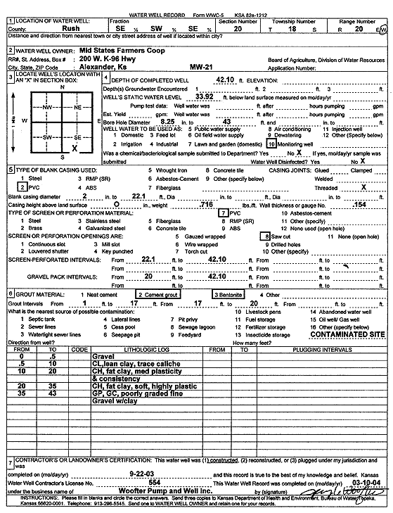
Specific Water Well Detail |
|
|
| Location Info | |||
| Owner: Mid-State Farmers Coop | Status: Constructed | ||
| Location: T18S, R20W, Sec. 20, SE SW SE | County: Rush | ||
| Directions: | |||
| Latitude: 38.4665878 | Longitude: -99.5538911 | Datum NAD 27 | |
| Latitude: 38.4666022 | Longitude: -99.5542831 | Datum NAD 83 | |
| Longitude and latitude calculated by Survey from township-range-section-quarter calls. Only good to within the quarter call accuracy. | |||
| View well on interactive map | |||
| General Info | ||
| Well Depth: 42.1 ft. | Elevation: ft. | |
| Static Water Level: 33.92 ft. | Est. Yield: gpm. | |
| Comp. Date: 22-Sep-2003 | Well Use: Monitoring well/observation/piezometer | |
| DWR Applic. #: | Other ID: MW 21 | |
| Driller Info | ||
| Driller: Woofter Pump & Well, Inc. | License #: 554 | |
| Scanned Form | View scan |
|
Chemical Sample Submitted?:
Water Well disinfected?: | ||
| Casing Info | ||
| Casing Type:
Casing Joints: |
Diam: in. to ft | |
| Casing height above land surface: in
Casing Weight: lbs/ft Wall thickness or gauge no.: | ||
| Screen and Perforation Info | ||
| Screen Type: | Screen Openings: | |
| Screen-perforated intervals | From: ft to ft | |
| Gravel pack intervals | From: ft to ft | |
| Grout Info | ||
| Grout used: | From: to ft | |
| Source of Possible Contamination | ||
| Source: | ||
| Direction from well: | Distance: ft | |
| Lithologic Log
(Log data entered by KGS.) | ||
| From: 0 ft. to .5 ft. | gravel | |
| From: .5 ft. to 10 ft. | lean clay, trace caliche | |
| From: 10 ft. to 20 ft. | fat clay, medium plasticity and consistency | |
| From: 20 ft. to 35 ft. | fat clay, soft, highly plastic | |
| From: 35 ft. to 43 ft. | poorly graded fine gravel with clay | |