|
|
|
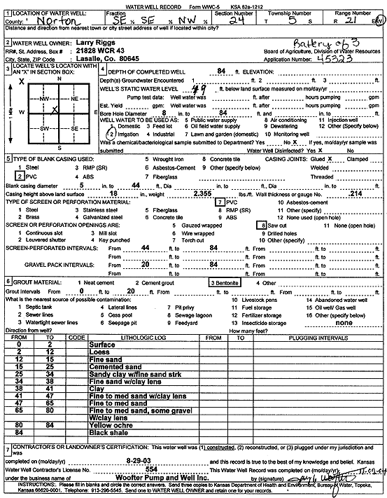
Specific Water Well Detail |
|
|
| Location Info | |||
| Owner: Riggs, Larry | Status: Constructed | ||
| Location: T5S, R21W, Sec. 24, SE SE NW | County: Norton | ||
| Directions: | |||
| Latitude: 39.6044756 | Longitude: -99.6380253 | Datum NAD 27 | |
| Latitude: 39.6044829 | Longitude: -99.638414 | Datum NAD 83 | |
| Longitude and latitude calculated by Survey from township-range-section-quarter calls. Only good to within the quarter call accuracy. | |||
| View well on interactive map | |||
| General Info | ||
| Well Depth: 84 ft. | Elevation: ft. | |
| Static Water Level: 49 ft. | Est. Yield: gpm. | |
| Comp. Date: 29-Aug-2003 | Well Use: Irrigation | |
| DWR Applic. #: 45323 | Other ID: battery of 3 | |
| Links | |
| No Wizard information available. | |
| View info from WIMAS Water Right Data base... | |
| Driller Info | ||
| Driller: Jay C. Woofter Pump & Well, Inc. | License #: 554 | |
| Scanned Form | View scan |
|
Chemical Sample Submitted?:
Water Well disinfected?: | ||
| Casing Info | ||
| Casing Type:
Casing Joints: |
Diam: in. to ft | |
| Casing height above land surface: in
Casing Weight: lbs/ft Wall thickness or gauge no.: | ||
| Screen and Perforation Info | ||
| Screen Type: | Screen Openings: | |
| Screen-perforated intervals | From: ft to ft | |
| Gravel pack intervals | From: ft to ft | |
| Grout Info | ||
| Grout used: | From: to ft | |
| Source of Possible Contamination | ||
| Source: | ||
| Direction from well: | Distance: ft | |
| Lithologic Log
(Log data entered by KGS.) | ||
| From: 0 ft. to 2 ft. | surface | |
| From: 2 ft. to 12 ft. | loess | |
| From: 12 ft. to 15 ft. | fine sand | |
| From: 15 ft. to 25 ft. | cemented sand | |
| From: 25 ft. to 34 ft. | sandy clay with fine sand streak | |
| From: 34 ft. to 38 ft. | fine sand with clay lens | |
| From: 38 ft. to 41 ft. | clay | |
| From: 41 ft. to 47 ft. | clay | |
| From: 47 ft. to 65 ft. | fine to medium sand | |
| From: 65 ft. to 80 ft. | fine to medium sand, some gravel, with clay lens | |
| From: 80 ft. to 84 ft. | yellow ochre | |
| From: 84 ft. to ft. | black shale | |