|
|
|
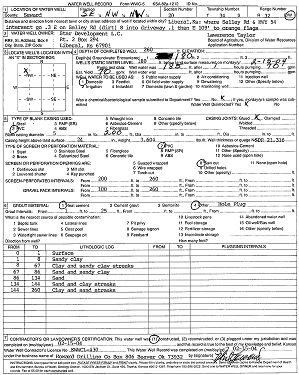
Specific Water Well Detail |
|
|
| Location Info | |||
| Owner: Star Development, L.C. | Status: Constructed | ||
| Location: T34S, R32W, Sec. 20, SE NW NW | County: Seward | ||
| Directions: from Liberal at Sally Rd and Hwy 54: .3 mi E on Salley Rd (dirt), .1 mi S into dwy, 109' E to Orange Flags | |||
| Latitude: 37.0804888 | Longitude: -100.8287937 | Datum NAD 27 | |
| Latitude: 37.080513 | Longitude: -100.8292334 | Datum NAD 83 | |
| Longitude and latitude calculated by Survey from township-range-section-quarter calls. Only good to within the quarter call accuracy. | |||
| View well on interactive map | |||
| General Info | ||
| Well Depth: 260 ft. | Elevation: ft. | |
| Static Water Level: 180 ft. | Est. Yield: 70 gpm. | |
| Comp. Date: 15-Feb-2004 | Well Use: Domestic | |
| DWR Applic. #: | Other ID: Lawrence Taylor | |
| Driller Info | ||
| Driller: Howard Drilling Company AG, LLC | License #: 430 | |
| Scanned Form | View scan |
|
Chemical Sample Submitted?:
Water Well disinfected?: | ||
| Casing Info | ||
| Casing Type:
Casing Joints: |
Diam: in. to ft | |
| Casing height above land surface: in
Casing Weight: lbs/ft Wall thickness or gauge no.: | ||
| Screen and Perforation Info | ||
| Screen Type: | Screen Openings: | |
| Screen-perforated intervals | From: ft to ft | |
| Gravel pack intervals | From: ft to ft | |
| Grout Info | ||
| Grout used: | From: to ft | |
| Source of Possible Contamination | ||
| Source: | ||
| Direction from well: | Distance: ft | |
| Lithologic Log
(Log data entered by KGS.) | ||
| From: 0 ft. to 1 ft. | surface | |
| From: 1 ft. to 8 ft. | sandy clay | |
| From: 8 ft. to 67 ft. | clay and sandy clay streaks | |
| From: 67 ft. to 86 ft. | sand and sandy clay | |
| From: 86 ft. to 134 ft. | sand | |
| From: 134 ft. to 144 ft. | sand and clay streaks | |
| From: 144 ft. to 260 ft. | clay and sand streaks | |