|
|
|
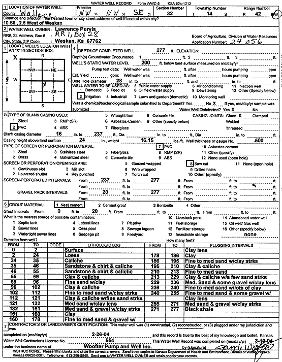
Specific Water Well Detail |
|
|
| Location Info | |||
| Owner: Purvis, Lawrence | Status: Reconstructed | ||
| Location: T14S, R42W, Sec. 32, NW NW SE | County: Wallace | ||
| Directions: from Weskan: 10 mi S, 2.5 mi W | |||
| Latitude: 38.7910703 | Longitude: -102.0091787 | Datum NAD 27 | |
| Latitude: 38.7910796 | Longitude: -102.0096342 | Datum NAD 83 | |
| Longitude and latitude calculated by Survey from township-range-section-quarter calls. Only good to within the quarter call accuracy. | |||
| View well on interactive map | |||
| General Info | ||
| Well Depth: 277 ft. | Elevation: ft. | |
| Static Water Level: 200 ft. | Est. Yield: gpm. | |
| Comp. Date: 26-Feb-2004 | Well Use: Irrigation | |
| DWR Applic. #: 24056 | Other ID: | |
| Links | |
| View info from Wizard Water Level Data base... | |
| View info from WIMAS Water Right Data base... | |
| Driller Info | ||
| Driller: Jay C. Woofter Pump & Well, Inc. | License #: 554 | |
| Scanned Form | View scan |
|
Chemical Sample Submitted?: No
Water Well disinfected?: Yes | ||
| Bore hole diameter: 28 inches to ft | ||
| Casing Info | ||
| Casing Type: PVC
Casing Joints: Glued |
Diam: 16 in. to 237 ft | |
| Casing height above land surface: 24 in
Casing Weight: 16.15 lbs/ft Wall thickness or gauge no.: .500 | ||
| Screen and Perforation Info | ||
| Screen Type: PVC | Screen Openings: Saw cut | |
| Screen-perforated intervals | From: 237 ft to 277 ft | |
| Gravel pack intervals | From: 20 ft to 277 ft | |
| Grout Info | ||
| Grout used: Neat cement | From: 0 to 20 ft | |
| Source of Possible Contamination | ||
| Source: none | ||
| Direction from well: | Distance: ft | |
| Lithologic Log
(Log data entered by KGS.) | ||
| From: 0 ft. to 2 ft. | Surface | |
| From: 2 ft. to 24 ft. | Loess | |
| From: 24 ft. to 35 ft. | Caliche | |
| From: 35 ft. to 46 ft. | Sandstone and chert and caliche | |
| From: 46 ft. to 55 ft. | Sandstone and chert and caliche | |
| From: 55 ft. to 69 ft. | Clay and caliche | |
| From: 69 ft. to 96 ft. | Fine sand with clay | |
| From: 96 ft. to 102 ft. | Clay and caliche | |
| From: 102 ft. to 112 ft. | Fine to med sand with clay streaks | |
| From: 112 ft. to 121 ft. | Clay and caliche with fine sand streaks | |
| From: 121 ft. to 132 ft. | Medium sand with clay lens | |
| From: 132 ft. to 151 ft. | Medium sand and gravel with clay streaks | |
| From: 151 ft. to 160 ft. | Clay | |
| From: 160 ft. to 178 ft. | Fine to medium sand and gravel with clay lens | |
| From: 178 ft. to 186 ft. | Clay | |
| From: 186 ft. to 195 ft. | Fine to medium sand with clay streaks | |
| From: 195 ft. to 210 ft. | Clay and caliche | |
| From: 210 ft. to 213 ft. | Fine to medium sand | |
| From: 213 ft. to 229 ft. | Clay and caliche with a few sand streaks | |
| From: 229 ft. to 236 ft. | Medium sand and some gravel with clay lens | |
| From: 236 ft. to 240 ft. | Fine to medium sand with lots of clay | |
| From: 240 ft. to 255 ft. | Fine to medium sand and some gravel with clay lens | |
| From: 255 ft. to 271 ft. | Medium sand and gravel with clay streaks | |
| From: 271 ft. to 277 ft. | Black shale | |