|
|
|
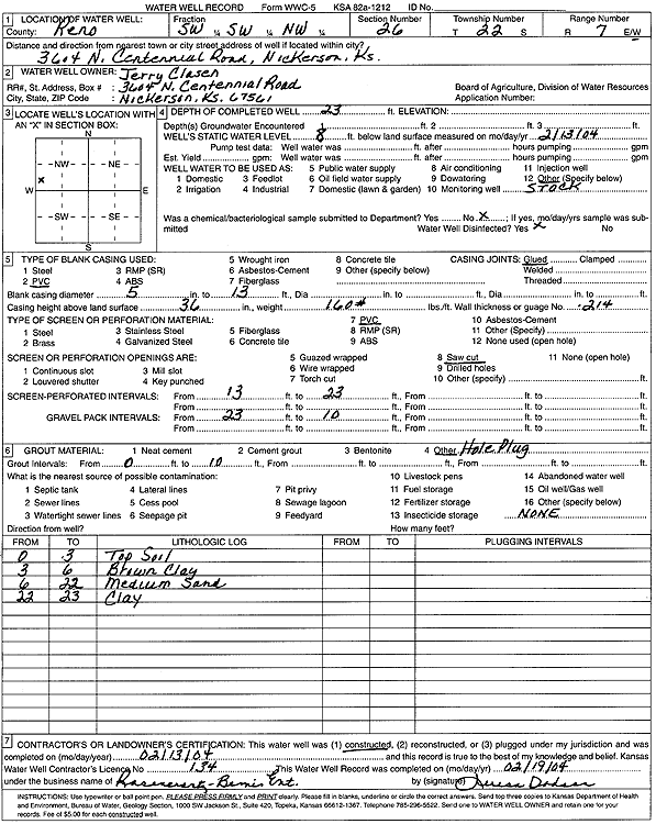
Specific Water Well Detail |
|
|
| Location Info | |||
| Owner: Clasen, Jerry | Status: Constructed | ||
| Location: T22S, R7W, Sec. 26, SW SW NW | County: Reno | ||
| Directions: 3604 N Centennial Rd, Nickerson | |||
| Latitude: 38.1092407 | Longitude: -98.0670958 | Datum NAD 27 | |
| Latitude: 38.1092521 | Longitude: -98.06743 | Datum NAD 83 | |
| Longitude and latitude calculated by Survey from township-range-section-quarter calls. Only good to within the quarter call accuracy. | |||
| View well on interactive map | |||
| General Info | ||
| Well Depth: 23 ft. | Elevation: ft. | |
| Static Water Level: 8 ft. | Est. Yield: gpm. | |
| Comp. Date: 13-Feb-2004 | Well Use: Domestic, Livestock | |
| DWR Applic. #: | Other ID: | |
| Driller Info | ||
| Driller: Rosencrantz-Bemis Enterprises, Inc. | License #: 134 | |
| Scanned Form | View scan |
|
Chemical Sample Submitted?:
Water Well disinfected?: | ||
| Casing Info | ||
| Casing Type:
Casing Joints: |
Diam: in. to ft | |
| Casing height above land surface: in
Casing Weight: lbs/ft Wall thickness or gauge no.: | ||
| Screen and Perforation Info | ||
| Screen Type: | Screen Openings: | |
| Screen-perforated intervals | From: ft to ft | |
| Gravel pack intervals | From: ft to ft | |
| Grout Info | ||
| Grout used: | From: to ft | |
| Source of Possible Contamination | ||
| Source: | ||
| Direction from well: | Distance: ft | |
| Lithologic Log
(Log data entered by KGS.) | ||
| From: 0 ft. to 3 ft. | top soil | |
| From: 3 ft. to 6 ft. | brown clay | |
| From: 6 ft. to 22 ft. | medium sand | |
| From: 22 ft. to 23 ft. | clay | |