|
|
|
Specific Water Well Detail |
|
|
| Location Info | |||
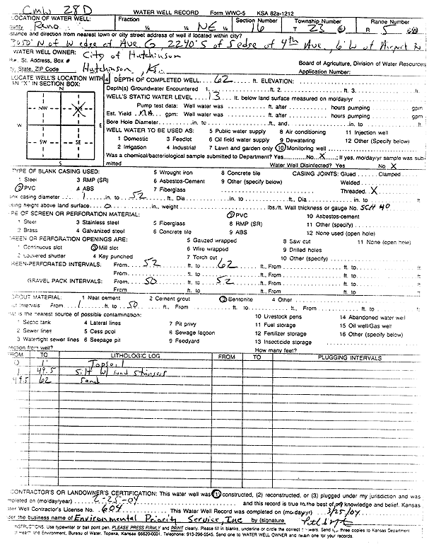
| Owner: City of Hutchinson | Status: Constructed | ||
| Location: T23S, R5W, Sec. 16, NE | County: Reno | ||
| Directions: from W edge of Ave G: 3050 feet N, 2240 feet S of S edge of 4th Ave, 6 feet W of Airport Rd | |||
| Latitude: 38.0539095 | Longitude: -97.8711472 | Datum NAD 27 | |
| Latitude: 38.0539207 | Longitude: -97.8714757 | Datum NAD 83 | |
| Longitude and latitude calculated by Survey from township-range-section-quarter calls. Only good to within the quarter call accuracy. | |||
| View well on interactive map | |||
| General Info | ||
| Well Depth: 62 ft. | Elevation: ft. | |
| Static Water Level: 13 ft. | Est. Yield: gpm. | |
| Comp. Date: 25-Feb-2004 | Well Use: Monitoring well/observation/piezometer | |
| DWR Applic. #: | Other ID: CMW 28D | |
| Driller Info | ||
| Driller: Environmental Priority Service, Inc. | License #: 604 | |
| Scanned Form | View scan |
|
Chemical Sample Submitted?:
Water Well disinfected?: | ||
| Casing Info | ||
| Casing Type:
Casing Joints: |
Diam: in. to ft | |
| Casing height above land surface: in
Casing Weight: lbs/ft Wall thickness or gauge no.: | ||
| Screen and Perforation Info | ||
| Screen Type: | Screen Openings: | |
| Screen-perforated intervals | From: ft to ft | |
| Gravel pack intervals | From: ft to ft | |
| Grout Info | ||
| Grout used: | From: to ft | |
| Source of Possible Contamination | ||
| Source: | ||
| Direction from well: | Distance: ft | |
| Lithologic Log
(Log data entered by KGS.) | ||
| From: 0 ft. to 1 ft. | top soil | |
| From: 1 ft. to 49.5 ft. | silt with sand stringers | |
| From: 49.5 ft. to 62 ft. | sand | |