|
|
|
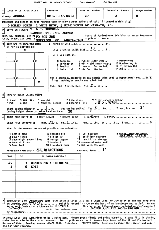
Specific Water Well Detail |
|
|
| Location Info | |||
| Owner: Russell, T. and J. | Status: Plugged | ||
| Location: T2S, R8W, Sec. 29, SE SE SE | County: Jewell | ||
| Directions: from Mankato, 3 mi N, 1 mi W, and 0.25 mi N | |||
| Latitude: 39.8436729 | Longitude: -98.2324447 | Datum NAD 27 | |
| Latitude: 39.8436857 | Longitude: -98.2327732 | Datum NAD 83 | |
| Longitude and latitude calculated by Survey from township-range-section-quarter calls. Only good to within the quarter call accuracy. | |||
| View well on interactive map | |||
| General Info | ||
| Well Depth: 45 ft. | Elevation: ft. | |
| Static Water Level: 13 ft. | Est. Yield: gpm. | |
| Comp. Date: 17-Jun-1998 | Well Use: Domestic | |
| DWR Applic. #: | Other ID: | |
| Driller Info | ||
| Driller: Water Quality Coordinator | License #: | |
| Scanned Form | View scan |
| Casing Info | ||
|
Casing Type:
Diam: in. Casing height above land surface: in | ||
| Grout Info | ||
| Grout used: | From: to ft | |
| Source of Possible Contamination | ||
| Source: | ||
| Direction from well: | Distance: ft | |