|
|
|
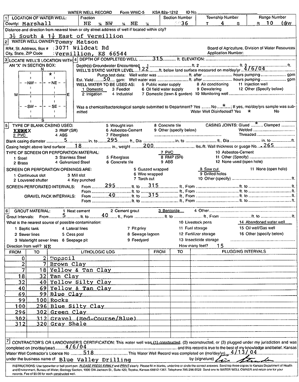
Specific Water Well Detail |
|
|
| Location Info | |||
| Owner: Matson, Tommy | Status: Constructed | ||
| Location: T4S, R10E, Sec. 36, NE NW NE | County: Marshall | ||
| Directions: from Vermillion: 3.5 mi S, 1.25 mi E | |||
| Latitude: 39.6668682 | Longitude: -96.2453356 | Datum NAD 27 | |
| Latitude: 39.6668661 | Longitude: -96.2456191 | Datum NAD 83 | |
| Longitude and latitude calculated by Survey from township-range-section-quarter calls. Only good to within the quarter call accuracy. | |||
| View well on interactive map | |||
| General Info | ||
| Well Depth: 315 ft. | Elevation: ft. | |
| Static Water Level: 122 ft. | Est. Yield: 50 gpm. | |
| Comp. Date: 06-Apr-2004 | Well Use: Domestic | |
| DWR Applic. #: | Other ID: | |
| Driller Info | ||
| Driller: Blue Valley Drilling | License #: 518 | |
| Scanned Form | View scan |
|
Chemical Sample Submitted?:
Water Well disinfected?: | ||
| Casing Info | ||
| Casing Type:
Casing Joints: |
Diam: in. to ft | |
| Casing height above land surface: in
Casing Weight: lbs/ft Wall thickness or gauge no.: | ||
| Screen and Perforation Info | ||
| Screen Type: | Screen Openings: | |
| Screen-perforated intervals | From: ft to ft | |
| Gravel pack intervals | From: ft to ft | |
| Grout Info | ||
| Grout used: | From: to ft | |
| Source of Possible Contamination | ||
| Source: | ||
| Direction from well: | Distance: ft | |
| Lithologic Log
(Log data entered by KGS.) | ||
| From: 0 ft. to 2 ft. | top soil | |
| From: 2 ft. to 7 ft. | brown clay | |
| From: 7 ft. to 18 ft. | yellow and tan clay | |
| From: 18 ft. to 32 ft. | tan clay | |
| From: 32 ft. to 40 ft. | yellow silty clay | |
| From: 40 ft. to 69 ft. | yellow and tan clay | |
| From: 69 ft. to 99 ft. | blue clay | |
| From: 99 ft. to 100 ft. | rocks | |
| From: 100 ft. to 296 ft. | blue silty clay | |
| From: 296 ft. to 302 ft. | green clay | |
| From: 302 ft. to 312 ft. | gravel, medium-coarse, blue | |
| From: 312 ft. to 320 ft. | gray shale | |