|
|
|
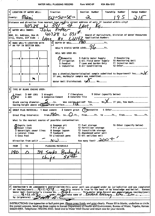
Specific Water Well Detail |
|
|
| Location Info | |||
| Owner: Prather, John | Status: Plugged | ||
| Location: T19S, R21E, Sec. 2, SW SW SE | County: Miami | ||
| Directions: 40728 W 391st St, Lane | |||
| Latitude: 38.4197088 | Longitude: -95.0552755 | Datum NAD 27 | |
| Latitude: 38.4197266 | Longitude: -95.0555221 | Datum NAD 83 | |
| Longitude and latitude calculated by Survey from township-range-section-quarter calls. Only good to within the quarter call accuracy. | |||
| View well on interactive map | |||
| General Info | ||
| Well Depth: 180 ft. | Elevation: ft. | |
| Static Water Level: 96 ft. | Est. Yield: gpm. | |
| Comp. Date: 01-Apr-2004 | Well Use: Domestic | |
| DWR Applic. #: | Other ID: | |
| Driller Info | ||
| Driller: Evans Energy Development, Inc. | License #: 561 | |
| Scanned Form | View scan |
| Casing Info | ||
|
Casing Type:
Diam: in. Casing height above land surface: in | ||
| Grout Info | ||
| Grout used: | From: to ft | |
| Source of Possible Contamination | ||
| Source: | ||
| Direction from well: | Distance: ft | |