|
|
|
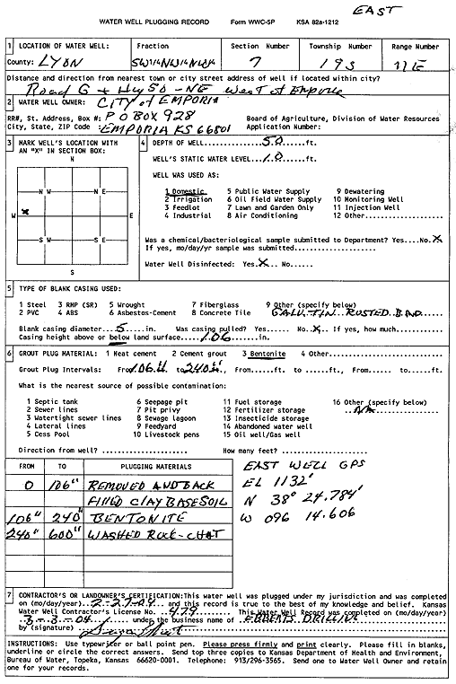
Specific Water Well Detail |
|
|
| Location Info | |||
| Owner: City of Emporia | Status: Plugged | ||
| Location: T19S, R11E, Sec. 7, SW NW NW | County: Lyon | ||
| Directions: NE of Rd G and Hwy 50, W of Emporia | |||
| Latitude: 38.4166746 | Longitude: -96.2429329 | Datum NAD 27 | |
| Latitude: 38.4166883 | Longitude: -96.2432084 | Datum NAD 83 | |
| Longitude and latitude calculated by Survey from township-range-section-quarter calls. Only good to within the quarter call accuracy. | |||
| View well on interactive map | |||
| General Info | ||
| Well Depth: 50 ft. | Elevation: ft. | |
| Static Water Level: 10 ft. | Est. Yield: gpm. | |
| Comp. Date: 27-Feb-2004 | Well Use: Domestic | |
| DWR Applic. #: | Other ID: East Well | |
| Driller Info | ||
| Driller: Grogan Ebberts Drilling | License #: 479 | |
| Scanned Form | View scan |
| Casing Info | ||
|
Casing Type:
Diam: in. Casing height above land surface: in | ||
| Grout Info | ||
| Grout used: | From: to ft | |
| Source of Possible Contamination | ||
| Source: | ||
| Direction from well: | Distance: ft | |