|
|
|
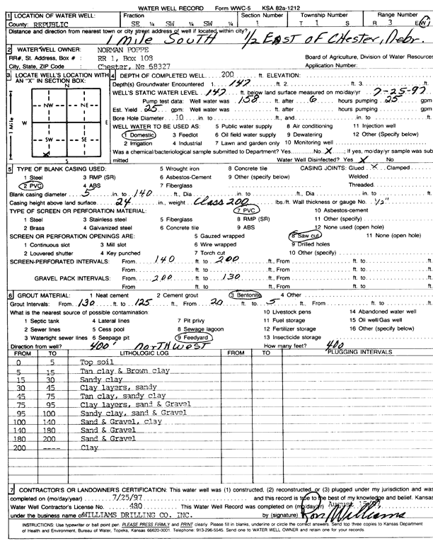
Specific Water Well Detail |
|
|
| Location Info | |||
| Owner: Poppe, Norman | Status: Constructed | ||
| Location: T1S, R3W, Sec. 1, SE SW SW | County: Republic | ||
| Directions: from Chester, NE, 1 mi S and 0.5 mi E | |||
| Latitude: 39.9872475 | Longitude: -97.6091599 | Datum NAD 27 | |
| Latitude: 39.987255 | Longitude: -97.6094798 | Datum NAD 83 | |
| Longitude and latitude calculated by Survey from township-range-section-quarter calls. Only good to within the quarter call accuracy. | |||
| View well on interactive map | |||
| General Info | ||
| Well Depth: 200 ft. | Elevation: ft. | |
| Static Water Level: 147 ft. | Est. Yield: 25 gpm. | |
| Comp. Date: 25-Jul-1997 | Well Use: Domestic | |
| DWR Applic. #: | Other ID: | |
| Driller Info | ||
| Driller: Ron Williams Drilling Co., Inc. | License #: 480 | |
| Scanned Form | View scan |
|
Chemical Sample Submitted?:
Water Well disinfected?: | ||
| Casing Info | ||
| Casing Type:
Casing Joints: |
Diam: in. to ft | |
| Casing height above land surface: in
Casing Weight: lbs/ft Wall thickness or gauge no.: | ||
| Screen and Perforation Info | ||
| Screen Type: | Screen Openings: | |
| Screen-perforated intervals | From: ft to ft | |
| Gravel pack intervals | From: ft to ft | |
| Grout Info | ||
| Grout used: | From: to ft | |
| Source of Possible Contamination | ||
| Source: | ||
| Direction from well: | Distance: ft | |
| Lithologic Log
(Log data entered by KGS.) | ||
| From: 0 ft. to 5 ft. | top soil | |
| From: 5 ft. to 15 ft. | tan clay and brown clay | |
| From: 15 ft. to 30 ft. | sandy clay | |
| From: 30 ft. to 45 ft. | clay layers, sandy | |
| From: 45 ft. to 75 ft. | tan clay, sandy clay | |
| From: 75 ft. to 95 ft. | clay layers, sand, and gravel | |
| From: 95 ft. to 100 ft. | sandy clay, sand, and gravel | |
| From: 100 ft. to 140 ft. | sand and gravel, clay | |
| From: 140 ft. to 180 ft. | sand and gravel | |
| From: 180 ft. to 200 ft. | sand and gravel | |