|
|
|
Specific Water Well Detail |
|
|
| Location Info | |||
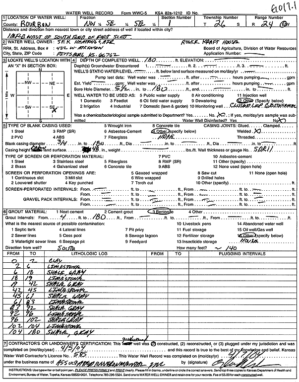
| Owner: Sek Heating and Air | Status: Constructed | ||
| Location: T26S, R24E, Sec. 1, NW SE SE | County: Bourbon | ||
| Directions: Roger Kraft House - from S end of Fort Scott: 1 mi W | |||
| Latitude: 37.8077903 | Longitude: -94.7268483 | Datum NAD 27 | |
| Latitude: 37.8078318 | Longitude: -94.7270889 | Datum NAD 83 | |
| Longitude and latitude calculated by Survey from township-range-section-quarter calls. Only good to within the quarter call accuracy. | |||
| View well on interactive map | |||
| General Info | ||
| Well Depth: 180 ft. | Elevation: ft. | |
| Static Water Level: ft. | Est. Yield: gpm. | |
| Comp. Date: 05-Apr-2004 | Well Use: Geothermal, Closed Loop, Vertical | |
| DWR Applic. #: | Other ID: GO17.1 | |
| Driller Info | ||
| Driller: Associated Environmental, Inc. | License #: 585 | |
| Scanned Form | View scan |
|
Chemical Sample Submitted?:
Water Well disinfected?: | ||
| Casing Info | ||
| Casing Type:
Casing Joints: |
Diam: in. to ft | |
| Casing height above land surface: in
Casing Weight: lbs/ft Wall thickness or gauge no.: | ||
| Screen and Perforation Info | ||
| Screen Type: | Screen Openings: | |
| Screen-perforated intervals | From: ft to ft | |
| Gravel pack intervals | From: ft to ft | |
| Grout Info | ||
| Grout used: | From: to ft | |
| Source of Possible Contamination | ||
| Source: | ||
| Direction from well: | Distance: ft | |
| Lithologic Log
(Log data entered by KGS.) | ||
| From: 0 ft. to 2 ft. | clay | |
| From: 2 ft. to 6 ft. | limestone | |
| From: 6 ft. to 18 ft. | shale, gray | |
| From: 18 ft. to 19 ft. | limestone | |
| From: 19 ft. to 42 ft. | shale, gray | |
| From: 42 ft. to 45 ft. | limestone | |
| From: 45 ft. to 61 ft. | shale, gray | |
| From: 61 ft. to 83 ft. | limestone | |
| From: 83 ft. to 92 ft. | shale, gray | |
| From: 92 ft. to 96 ft. | limestone | |
| From: 96 ft. to 102 ft. | shale, gray | |
| From: 102 ft. to 104 ft. | limestone | |
| From: 104 ft. to 180 ft. | shale, gray | |