|
|
|
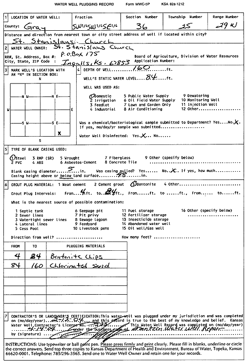
Specific Water Well Detail |
|
|
| Location Info | |||
| Owner: Saint Stanislaus Church | Status: Plugged | ||
| Location: T25S, R29W, Sec. 36, SW SW SE | County: Gray | ||
| Directions: | |||
| Latitude: 37.8285861 | Longitude: -100.4544855 | Datum NAD 27 | |
| Latitude: 37.8286078 | Longitude: -100.4549115 | Datum NAD 83 | |
| Longitude and latitude calculated by Survey from township-range-section-quarter calls. Only good to within the quarter call accuracy. | |||
| View well on interactive map | |||
| General Info | ||
| Well Depth: 160 ft. | Elevation: ft. | |
| Static Water Level: 84 ft. | Est. Yield: gpm. | |
| Comp. Date: 12-Feb-2004 | Well Use: Domestic | |
| DWR Applic. #: | Other ID: | |
| Driller Info | ||
| Driller: Ed Jantzen Water Well Repair | License #: 533 | |
| Scanned Form | View scan |
| Casing Info | ||
|
Casing Type:
Diam: in. Casing height above land surface: in | ||
| Grout Info | ||
| Grout used: | From: to ft | |
| Source of Possible Contamination | ||
| Source: | ||
| Direction from well: | Distance: ft | |