|
|
|
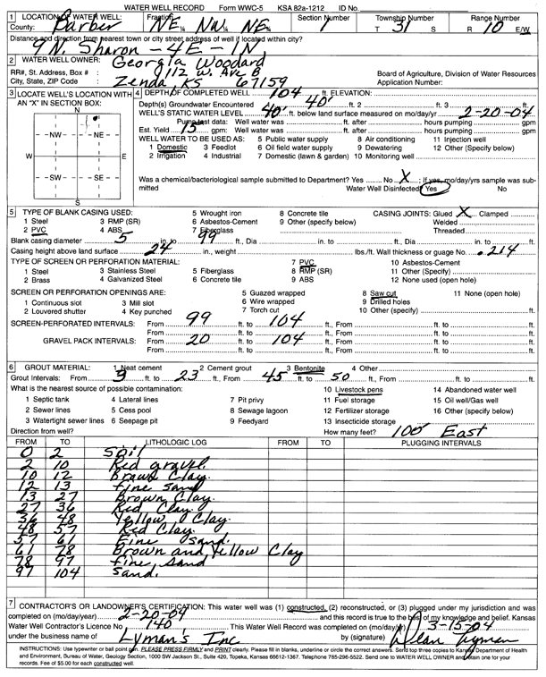
Specific Water Well Detail |
|
|
| Location Info | |||
| Owner: Woodard, Georgia | Status: Constructed | ||
| Location: T31S, R10W, Sec. 1, NE NW NE | County: Barber | ||
| Directions: from Sharon, 9 mi N, 4 mi E, 1 mi N | |||
| Latitude: 37.3830781 | Longitude: -98.3548201 | Datum NAD 27 | |
| Latitude: 37.3830982 | Longitude: -98.3551718 | Datum NAD 83 | |
| Longitude and latitude calculated by Survey from township-range-section-quarter calls. Only good to within the quarter call accuracy. | |||
| View well on interactive map | |||
| General Info | ||
| Well Depth: 104 ft. | Elevation: ft. | |
| Static Water Level: 40 ft. | Est. Yield: 15 gpm. | |
| Comp. Date: 20-Feb-2004 | Well Use: Domestic | |
| DWR Applic. #: | Other ID: | |
| Driller Info | ||
| Driller: Dean L. Lyman, Inc. | License #: 140 | |
| Scanned Form | View scan |
|
Chemical Sample Submitted?:
Water Well disinfected?: | ||
| Casing Info | ||
| Casing Type:
Casing Joints: |
Diam: in. to ft | |
| Casing height above land surface: in
Casing Weight: lbs/ft Wall thickness or gauge no.: | ||
| Screen and Perforation Info | ||
| Screen Type: | Screen Openings: | |
| Screen-perforated intervals | From: ft to ft | |
| Gravel pack intervals | From: ft to ft | |
| Grout Info | ||
| Grout used: | From: to ft | |
| Source of Possible Contamination | ||
| Source: | ||
| Direction from well: | Distance: ft | |
| Lithologic Log
(Log data entered by KGS.) | ||
| From: 0 ft. to 2 ft. | soil | |
| From: 2 ft. to 10 ft. | red gravel | |
| From: 10 ft. to 12 ft. | brown clay | |
| From: 12 ft. to 13 ft. | fine sand | |
| From: 13 ft. to 27 ft. | brown clay | |
| From: 27 ft. to 36 ft. | red clay | |
| From: 36 ft. to 48 ft. | yellow clay | |
| From: 48 ft. to 57 ft. | red clay | |
| From: 57 ft. to 61 ft. | fine sand | |
| From: 61 ft. to 78 ft. | brown and yellow clay | |
| From: 78 ft. to 97 ft. | fine sand | |
| From: 97 ft. to 104 ft. | sand | |