|
|
|
Specific Water Well Detail |
|
|
| Location Info | |||
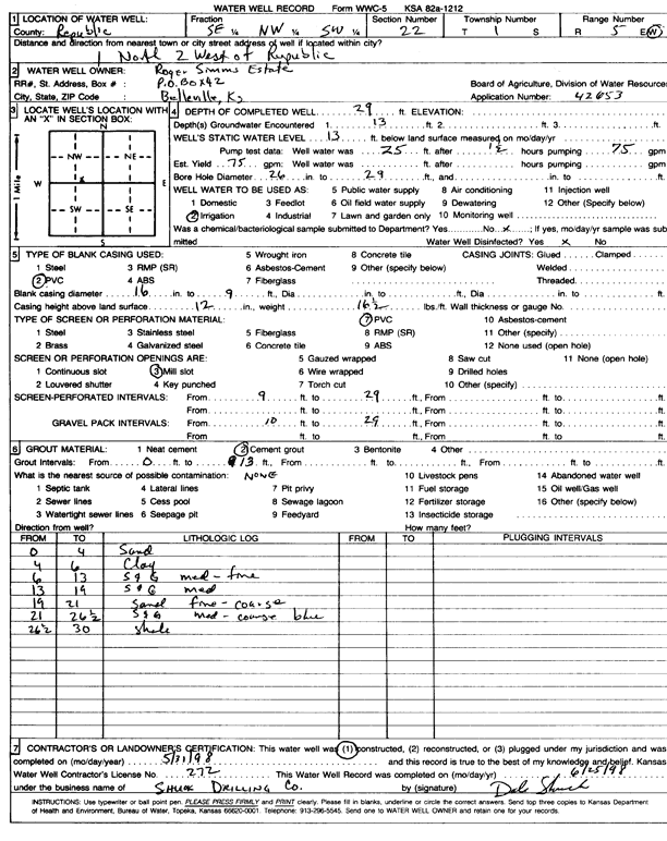
| Owner: Roger Simms Estate | Status: Constructed | ||
| Location: T1S, R5W, Sec. 22, SE NW SW | County: Republic | ||
| Directions: from Republic, 1 mi N and 2 mi W | |||
| Latitude: 39.9480717 | Longitude: -97.8724631 | Datum NAD 27 | |
| Latitude: 39.948083 | Longitude: -97.872784 | Datum NAD 83 | |
| Longitude and latitude calculated by Survey from township-range-section-quarter calls. Only good to within the quarter call accuracy. | |||
| View well on interactive map | |||
| General Info | ||
| Well Depth: 29 ft. | Elevation: ft. | |
| Static Water Level: 13 ft. | Est. Yield: 75 gpm. | |
| Comp. Date: 31-May-1998 | Well Use: Irrigation | |
| DWR Applic. #: 42653 | Other ID: | |
| Links | |
| No Wizard information available. | |
| View info from WIMAS Water Right Data base... | |
| Driller Info | ||
| Driller: Dale Shuck Drilling Co. | License #: 272 | |
| Scanned Form | View scan |
|
Chemical Sample Submitted?:
Water Well disinfected?: | ||
| Casing Info | ||
| Casing Type:
Casing Joints: |
Diam: in. to ft | |
| Casing height above land surface: in
Casing Weight: lbs/ft Wall thickness or gauge no.: | ||
| Screen and Perforation Info | ||
| Screen Type: | Screen Openings: | |
| Screen-perforated intervals | From: ft to ft | |
| Gravel pack intervals | From: ft to ft | |
| Grout Info | ||
| Grout used: | From: to ft | |
| Source of Possible Contamination | ||
| Source: | ||
| Direction from well: | Distance: ft | |
| Lithologic Log
(Log data entered by KGS.) | ||
| From: 0 ft. to 4 ft. | sand | |
| From: 4 ft. to 6 ft. | clay | |
| From: 6 ft. to 13 ft. | sand and gravel, medium-fine | |
| From: 13 ft. to 19 ft. | sand and gravel, medium | |
| From: 19 ft. to 21 ft. | sand, fine-coarse | |
| From: 21 ft. to 26.5 ft. | sand and gravel, medium-coarse, blue | |
| From: 26.5 ft. to 30 ft. | shale | |