|
|
|
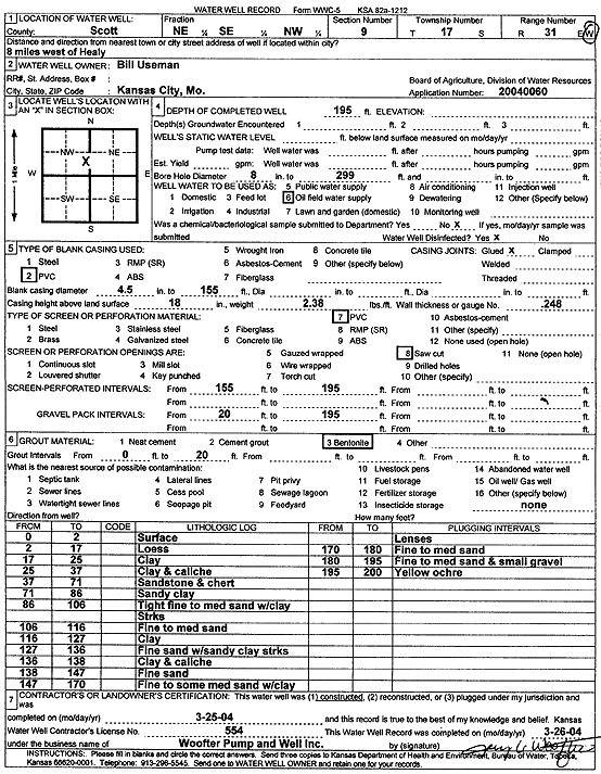
Specific Water Well Detail |
|
|
| Location Info | |||
| Owner: Useman, Bill | Status: Constructed | ||
| Location: T17S, R31W, Sec. 9, NE SE NW | County: Scott | ||
| Directions: from Healy: 8 mi W | |||
| Latitude: 38.594572 | Longitude: -100.7523472 | Datum NAD 27 | |
| Latitude: 38.5945883 | Longitude: -100.752771 | Datum NAD 83 | |
| Longitude and latitude calculated by Survey from township-range-section-quarter calls. Only good to within the quarter call accuracy. | |||
| View well on interactive map | |||
| General Info | ||
| Well Depth: 195 ft. | Elevation: ft. | |
| Static Water Level: ft. | Est. Yield: gpm. | |
| Comp. Date: 25-Mar-2004 | Well Use: Oil Field Water Supply | |
| DWR Applic. #: 20040060 | Other ID: | |
| Links | |
| No Wizard information available. | |
| View info from WIMAS Water Right Data base... | |
| Driller Info | ||
| Driller: Jay C. Woofter Pump & Well, Inc. | License #: 554 | |
| Scanned Form | View scan |
|
Chemical Sample Submitted?:
Water Well disinfected?: | ||
| Casing Info | ||
| Casing Type:
Casing Joints: |
Diam: in. to ft | |
| Casing height above land surface: in
Casing Weight: lbs/ft Wall thickness or gauge no.: | ||
| Screen and Perforation Info | ||
| Screen Type: | Screen Openings: | |
| Screen-perforated intervals | From: ft to ft | |
| Gravel pack intervals | From: ft to ft | |
| Grout Info | ||
| Grout used: | From: to ft | |
| Source of Possible Contamination | ||
| Source: | ||
| Direction from well: | Distance: ft | |
| Lithologic Log
(Log data entered by KGS.) | ||
| From: 0 ft. to 2 ft. | surface | |
| From: 2 ft. to 17 ft. | loess | |
| From: 17 ft. to 25 ft. | clay | |
| From: 25 ft. to 37 ft. | clay and caliche | |
| From: 37 ft. to 71 ft. | sandstone and chert | |
| From: 71 ft. to 86 ft. | sandy clay | |
| From: 86 ft. to 106 ft. | tight fine to med sand with clay streaks | |
| From: 106 ft. to 116 ft. | fine to med sand | |
| From: 116 ft. to 127 ft. | clay | |
| From: 127 ft. to 136 ft. | fine sand with sandy clay streaks | |
| From: 136 ft. to 138 ft. | clay and caliche | |
| From: 138 ft. to 147 ft. | fine sand | |
| From: 147 ft. to 170 ft. | fine to some med sand with clay lenses | |
| From: 170 ft. to 180 ft. | fine to med sand | |
| From: 180 ft. to 195 ft. | fine to med sand and small gravel | |
| From: 195 ft. to 200 ft. | yellow ochre | |