|
|
|
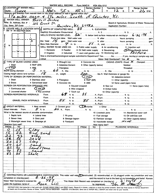
Specific Water Well Detail |
|
|
| Location Info | |||
| Owner: Jarboe, Russell | Status: Constructed | ||
| Location: T12S, R26W, Sec. 3, NW SE NE | County: Gove | ||
| Directions: from Quinter: 1.5 mi E and 1.5 mi S | |||
| Latitude: 39.0409196 | Longitude: -100.1891171 | Datum NAD 27 | |
| Latitude: 39.040927 | Longitude: -100.1895262 | Datum NAD 83 | |
| Longitude and latitude calculated by Survey from township-range-section-quarter calls. Only good to within the quarter call accuracy. | |||
| View well on interactive map | |||
| General Info | ||
| Well Depth: 85 ft. | Elevation: ft. | |
| Static Water Level: 52 ft. | Est. Yield: 15 gpm. | |
| Comp. Date: 26-Jun-1998 | Well Use: Domestic, Livestock | |
| DWR Applic. #: | Other ID: | |
| Driller Info | ||
| Driller: Aqua Pump LLC | License #: 489 | |
| Scanned Form | View scan |
|
Chemical Sample Submitted?:
Water Well disinfected?: | ||
| Casing Info | ||
| Casing Type:
Casing Joints: |
Diam: in. to ft | |
| Casing height above land surface: in
Casing Weight: lbs/ft Wall thickness or gauge no.: | ||
| Screen and Perforation Info | ||
| Screen Type: | Screen Openings: | |
| Screen-perforated intervals | From: ft to ft | |
| Gravel pack intervals | From: ft to ft | |
| Grout Info | ||
| Grout used: | From: to ft | |
| Source of Possible Contamination | ||
| Source: | ||
| Direction from well: | Distance: ft | |
| Lithologic Log
(Log data entered by KGS.) | ||
| From: 0 ft. to 15 ft. | Clay | |
| From: 15 ft. to 22 ft. | Fine sand | |
| From: 22 ft. to 32 ft. | Clay | |
| From: 32 ft. to 55 ft. | Sand | |
| From: 55 ft. to 57 ft. | Clay | |
| From: 57 ft. to 65 ft. | Sand | |
| From: 65 ft. to 70 ft. | Sandstone | |
| From: 70 ft. to 83 ft. | Sand | |
| From: 83 ft. to 85 ft. | Shale | |