|
|
|
Specific Water Well Detail |
|
|
| Location Info | |||
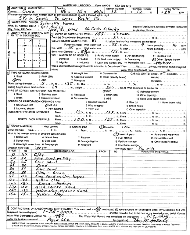
| Owner: Selensky Farms | Status: Constructed | ||
| Location: T12S, R28W, Sec. 12, NE NE NW | County: Gove | ||
| Directions: from Park: 5.5 mi S and 0.5 mi W | |||
| Latitude: 39.0311721 | Longitude: -100.3812982 | Datum NAD 27 | |
| Latitude: 39.0311802 | Longitude: -100.3817119 | Datum NAD 83 | |
| Longitude and latitude calculated by Survey from township-range-section-quarter calls. Only good to within the quarter call accuracy. | |||
| View well on interactive map | |||
| General Info | ||
| Well Depth: 155 ft. | Elevation: ft. | |
| Static Water Level: 81 ft. | Est. Yield: 35 gpm. | |
| Comp. Date: 25-Jan-2000 | Well Use: Domestic, Livestock | |
| DWR Applic. #: | Other ID: | |
| Driller Info | ||
| Driller: Aqua Pump LLC | License #: 489 | |
| Scanned Form | View scan |
|
Chemical Sample Submitted?:
Water Well disinfected?: | ||
| Casing Info | ||
| Casing Type:
Casing Joints: |
Diam: in. to ft | |
| Casing height above land surface: in
Casing Weight: lbs/ft Wall thickness or gauge no.: | ||
| Screen and Perforation Info | ||
| Screen Type: | Screen Openings: | |
| Screen-perforated intervals | From: ft to ft | |
| Gravel pack intervals | From: ft to ft | |
| Grout Info | ||
| Grout used: | From: to ft | |
| Source of Possible Contamination | ||
| Source: | ||
| Direction from well: | Distance: ft | |
| Lithologic Log
(Log data entered by KGS.) | ||
| From: 0 ft. to 22 ft. | Clay | |
| From: 22 ft. to 50 ft. | Fine sand with clay | |
| From: 50 ft. to 65 ft. | Fine sand | |
| From: 65 ft. to 80 ft. | Sand | |
| From: 80 ft. to 84 ft. | Fine sand | |
| From: 84 ft. to 88 ft. | Clay, brown | |
| From: 88 ft. to 100 ft. | Fine sand with clay layers | |
| From: 100 ft. to 103 ft. | Yellow clay | |
| From: 103 ft. to 130 ft. | Sand, medium | |
| From: 130 ft. to 150 ft. | Good coarse sand | |
| From: 150 ft. to 152 ft. | Yellow clay with some sand | |
| From: 152 ft. to 155 ft. | Yellow clay | |