|
|
|
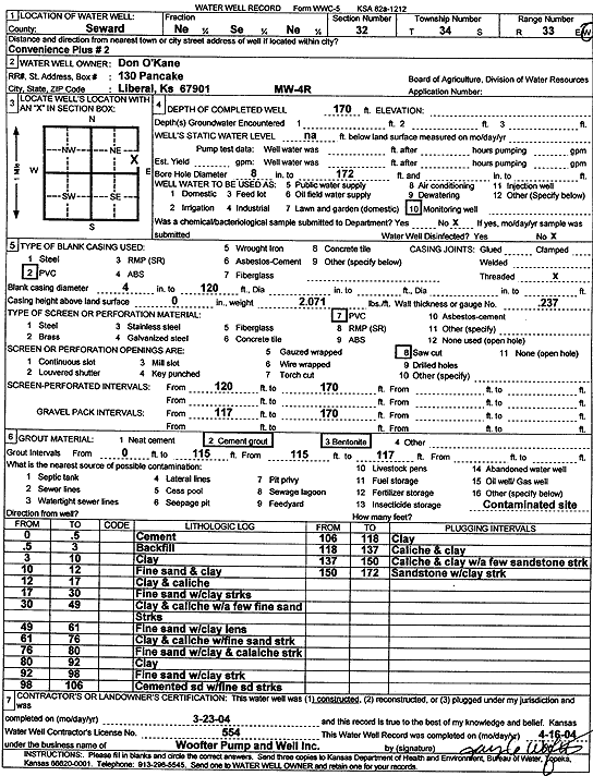
Specific Water Well Detail |
|
|
| Location Info | |||
| Owner: O'Kane, Don | Status: Constructed | ||
| Location: T34S, R33W, Sec. 32, NE SE NE | County: Seward | ||
| Directions: Convenience Plus 2 | |||
| Latitude: 37.0497236 | Longitude: -100.9229636 | Datum NAD 27 | |
| Latitude: 37.0497491 | Longitude: -100.923407 | Datum NAD 83 | |
| Longitude and latitude calculated by Survey from township-range-section-quarter calls. Only good to within the quarter call accuracy. | |||
| View well on interactive map | |||
| General Info | ||
| Well Depth: 170 ft. | Elevation: ft. | |
| Static Water Level: ft. | Est. Yield: gpm. | |
| Comp. Date: 23-Mar-2004 | Well Use: Monitoring well/observation/piezometer | |
| DWR Applic. #: | Other ID: MW 4 R | |
| Driller Info | ||
| Driller: Jay C. Woofter Pump & Well, Inc. | License #: 554 | |
| Scanned Form | View scan |
|
Chemical Sample Submitted?:
Water Well disinfected?: | ||
| Casing Info | ||
| Casing Type:
Casing Joints: |
Diam: in. to ft | |
| Casing height above land surface: in
Casing Weight: lbs/ft Wall thickness or gauge no.: | ||
| Screen and Perforation Info | ||
| Screen Type: | Screen Openings: | |
| Screen-perforated intervals | From: ft to ft | |
| Gravel pack intervals | From: ft to ft | |
| Grout Info | ||
| Grout used: | From: to ft | |
| Source of Possible Contamination | ||
| Source: | ||
| Direction from well: | Distance: ft | |
| Lithologic Log
(Log data entered by KGS.) | ||
| From: 0 ft. to .5 ft. | cement | |
| From: .5 ft. to 3 ft. | backfill | |
| From: 3 ft. to 10 ft. | clay | |
| From: 10 ft. to 12 ft. | fine sand and clay | |
| From: 12 ft. to 17 ft. | clay and caliche | |
| From: 17 ft. to 30 ft. | fine sand with clay streaks | |
| From: 30 ft. to 49 ft. | clay and caliche with a few fine sand streaks | |
| From: 49 ft. to 61 ft. | fine sand with clay lens | |
| From: 61 ft. to 76 ft. | clay and caliche with fine sand streak | |
| From: 76 ft. to 80 ft. | fine sand with clay and caliche streak | |
| From: 80 ft. to 92 ft. | clay | |
| From: 92 ft. to 98 ft. | fine sand with clay strk | |
| From: 98 ft. to 106 ft. | cemented sd with fine sd streaks | |
| From: 106 ft. to 118 ft. | clay | |
| From: 118 ft. to 137 ft. | caliche and clay | |
| From: 137 ft. to 150 ft. | caliche and clay with a few sandstone strk | |
| From: 150 ft. to 172 ft. | sandstone with clay strk | |