|
|
|
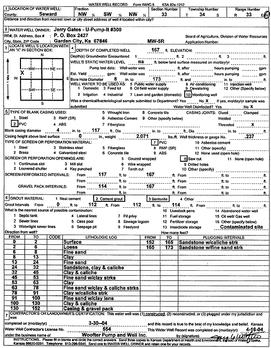
Specific Water Well Detail |
|
|
| Location Info | |||
| Owner: U-Pump-It 300 | Status: Constructed | ||
| Location: T34S, R33W, Sec. 33, NW SW NW | County: Seward | ||
| Directions: | |||
| Latitude: 37.0497256 | Longitude: -100.9206967 | Datum NAD 27 | |
| Latitude: 37.049751 | Longitude: -100.92114 | Datum NAD 83 | |
| Longitude and latitude calculated by Survey from township-range-section-quarter calls. Only good to within the quarter call accuracy. | |||
| View well on interactive map | |||
| General Info | ||
| Well Depth: 167 ft. | Elevation: ft. | |
| Static Water Level: ft. | Est. Yield: gpm. | |
| Comp. Date: 30-Mar-2004 | Well Use: Monitoring well/observation/piezometer | |
| DWR Applic. #: | Other ID: MW 5 R | |
| Driller Info | ||
| Driller: Jay C. Woofter Pump & Well, Inc. | License #: 554 | |
| Scanned Form | View scan |
|
Chemical Sample Submitted?:
Water Well disinfected?: | ||
| Casing Info | ||
| Casing Type:
Casing Joints: |
Diam: in. to ft | |
| Casing height above land surface: in
Casing Weight: lbs/ft Wall thickness or gauge no.: | ||
| Screen and Perforation Info | ||
| Screen Type: | Screen Openings: | |
| Screen-perforated intervals | From: ft to ft | |
| Gravel pack intervals | From: ft to ft | |
| Grout Info | ||
| Grout used: | From: to ft | |
| Source of Possible Contamination | ||
| Source: | ||
| Direction from well: | Distance: ft | |
| Lithologic Log
(Log data entered by KGS.) | ||
| From: 0 ft. to 2 ft. | surface | |
| From: 2 ft. to 6 ft. | loess | |
| From: 6 ft. to 8 ft. | fine sand | |
| From: 8 ft. to 13 ft. | clay | |
| From: 13 ft. to 24 ft. | fine sand | |
| From: 24 ft. to 32 ft. | sandstone, clay and caliche | |
| From: 32 ft. to 45 ft. | clay and caliche | |
| From: 45 ft. to 53 ft. | fine sand with clay streaks | |
| From: 53 ft. to 63 ft. | clay | |
| From: 63 ft. to 78 ft. | fine sand with clay and caliche streaks | |
| From: 78 ft. to 91 ft. | clay with caliche streak | |
| From: 91 ft. to 100 ft. | fine sand with clay lens | |
| From: 100 ft. to 130 ft. | clay and caliche | |
| From: 130 ft. to 152 ft. | casing and gravel pack | |
| From: 152 ft. to 165 ft. | sandstone with caliche strk | |
| From: 165 ft. to 173 ft. | sandstone with fine sand strk | |