|
|
|
Specific Water Well Detail |
|
|
| Location Info | |||
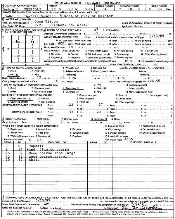
| Owner: Tilton, Gene | Status: Reconstructed | ||
| Location: T10S, R26W, Sec. 34, SE NW NW | County: Sheridan | ||
| Directions: from Quinter: 5 mi N, 1.5 mi E, .25 mi S, .5 mi W | |||
| Latitude: 39.1440444 | Longitude: -100.2161742 | Datum NAD 27 | |
| Latitude: 39.1440505 | Longitude: -100.2165852 | Datum NAD 83 | |
| Longitude and latitude calculated by Survey from township-range-section-quarter calls. Only good to within the quarter call accuracy. | |||
| View well on interactive map | |||
| General Info | ||
| Well Depth: 37 ft. | Elevation: ft. | |
| Static Water Level: 12 ft. | Est. Yield: 400 gpm. | |
| Comp. Date: 25-Jun-1997 | Well Use: Irrigation | |
| DWR Applic. #: | Other ID: | |
| Links | |
| No Wizard information available. | |
| View info from WIMAS Water Right Data base... | |
| Driller Info | ||
| Driller: Aqua Pump LLC | License #: 489 | |
| Scanned Form | View scan |
|
Chemical Sample Submitted?:
Water Well disinfected?: | ||
| Casing Info | ||
| Casing Type:
Casing Joints: |
Diam: in. to ft | |
| Casing height above land surface: in
Casing Weight: lbs/ft Wall thickness or gauge no.: | ||
| Screen and Perforation Info | ||
| Screen Type: | Screen Openings: | |
| Screen-perforated intervals | From: ft to ft | |
| Gravel pack intervals | From: ft to ft | |
| Grout Info | ||
| Grout used: | From: to ft | |
| Source of Possible Contamination | ||
| Source: | ||
| Direction from well: | Distance: ft | |