|
|
|
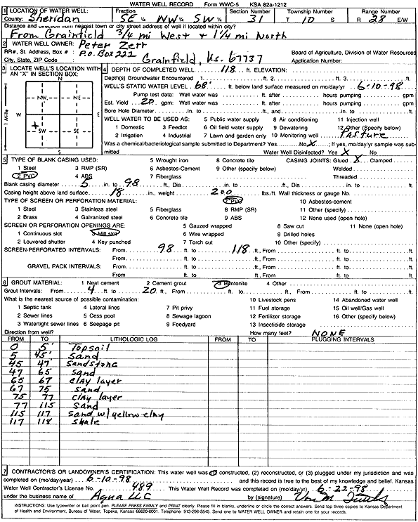
Specific Water Well Detail |
|
|
| Location Info | |||
| Owner: Zerr, Peter | Status: Constructed | ||
| Location: T10S, R28W, Sec. 31, SE NW SW | County: Sheridan | ||
| Directions: from Grainfield: .75 mi W, 1.25 mi N | |||
| Latitude: 39.1376471 | Longitude: -100.4940291 | Datum NAD 27 | |
| Latitude: 39.1376545 | Longitude: -100.4944465 | Datum NAD 83 | |
| Longitude and latitude calculated by Survey from township-range-section-quarter calls. Only good to within the quarter call accuracy. | |||
| View well on interactive map | |||
| General Info | ||
| Well Depth: 118 ft. | Elevation: ft. | |
| Static Water Level: 68 ft. | Est. Yield: 20 gpm. | |
| Comp. Date: 10-Jun-1998 | Well Use: Domestic, Livestock | |
| DWR Applic. #: | Other ID: | |
| Driller Info | ||
| Driller: Aqua Pump LLC | License #: 489 | |
| Scanned Form | View scan |
|
Chemical Sample Submitted?:
Water Well disinfected?: | ||
| Casing Info | ||
| Casing Type:
Casing Joints: |
Diam: in. to ft | |
| Casing height above land surface: in
Casing Weight: lbs/ft Wall thickness or gauge no.: | ||
| Screen and Perforation Info | ||
| Screen Type: | Screen Openings: | |
| Screen-perforated intervals | From: ft to ft | |
| Gravel pack intervals | From: ft to ft | |
| Grout Info | ||
| Grout used: | From: to ft | |
| Source of Possible Contamination | ||
| Source: | ||
| Direction from well: | Distance: ft | |
| Lithologic Log
(Log data entered by KGS.) | ||
| From: 0 ft. to 5 ft. | Top soil | |
| From: 5 ft. to 45 ft. | Sand | |
| From: 45 ft. to 47 ft. | Sandstone | |
| From: 47 ft. to 65 ft. | Sand | |
| From: 65 ft. to 67 ft. | Clay layer | |
| From: 67 ft. to 75 ft. | Sand | |
| From: 75 ft. to 77 ft. | Clay layer | |
| From: 77 ft. to 115 ft. | Sand | |
| From: 115 ft. to 117 ft. | Sand with yellow clay | |
| From: 117 ft. to 118 ft. | Shale | |