|
|
|
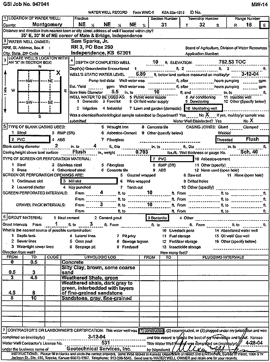
Specific Water Well Detail |
|
|
| Location Info | |||
| Owner: Sparks, Sam Jr. | Status: Constructed | ||
| Location: T32S, R16E, Sec. 31, NE NE NE | County: Montgomery | ||
| Directions: from NE corner, Main and Bridge, Independence: 35' E, 30' N | |||
| Latitude: 37.2243216 | Longitude: -95.6938779 | Datum NAD 27 | |
| Latitude: 37.2243907 | Longitude: -95.6941353 | Datum NAD 83 | |
| Longitude and latitude calculated by Survey from township-range-section-quarter calls. Only good to within the quarter call accuracy. | |||
| View well on interactive map | |||
| General Info | ||
| Well Depth: 10 ft. | Elevation: 782.53 ft. | |
| Static Water Level: 6.89 ft. | Est. Yield: gpm. | |
| Comp. Date: 12-Mar-2004 | Well Use: Monitoring well/observation/piezometer | |
| DWR Applic. #: | Other ID: MW 14 | |
| Driller Info | ||
| Driller: Geotechnical Services, Inc. | License #: 531 | |
| Scanned Form | View scan |
|
Chemical Sample Submitted?:
Water Well disinfected?: | ||
| Casing Info | ||
| Casing Type:
Casing Joints: |
Diam: in. to ft | |
| Casing height above land surface: in
Casing Weight: lbs/ft Wall thickness or gauge no.: | ||
| Screen and Perforation Info | ||
| Screen Type: | Screen Openings: | |
| Screen-perforated intervals | From: ft to ft | |
| Gravel pack intervals | From: ft to ft | |
| Grout Info | ||
| Grout used: | From: to ft | |
| Source of Possible Contamination | ||
| Source: | ||
| Direction from well: | Distance: ft | |
| Lithologic Log
(Log data entered by KGS.) | ||
| From: 0 ft. to .5 ft. | concrete | |
| From: .5 ft. to 3 ft. | silty clay, brown, with some coarse sand | |
| From: 3 ft. to 4.5 ft. | weathered shale, green | |
| From: 4.5 ft. to 8 ft. | weathered shale, dark gray to green, interbedded with layers of fine sandstone | |
| From: 8 ft. to 10 ft. | fine sandstone, gray | |