|
|
|
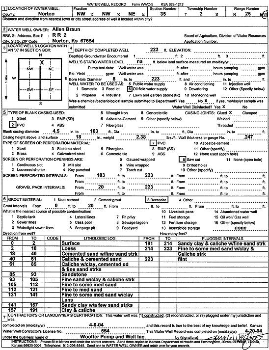
Specific Water Well Detail |
|
|
| Location Info | |||
| Owner: Braun, Allen | Status: Constructed | ||
| Location: T2S, R25W, Sec. 35, NW NW NE | County: Norton | ||
| Directions: | |||
| Latitude: 39.8412549 | Longitude: -100.103439 | Datum NAD 27 | |
| Latitude: 39.84126 | Longitude: -100.1038492 | Datum NAD 83 | |
| Longitude and latitude calculated by Survey from township-range-section-quarter calls. Only good to within the quarter call accuracy. | |||
| View well on interactive map | |||
| General Info | ||
| Well Depth: 223 ft. | Elevation: ft. | |
| Static Water Level: ft. | Est. Yield: gpm. | |
| Comp. Date: 06-Apr-2004 | Well Use: Oil Field Water Supply | |
| DWR Applic. #: | Other ID: | |
| Links | |
| No Wizard information available. | |
| View info from WIMAS Water Right Data base... | |
| Driller Info | ||
| Driller: Jay C. Woofter Pump & Well, Inc. | License #: 554 | |
| Scanned Form | View scan |
|
Chemical Sample Submitted?:
Water Well disinfected?: | ||
| Casing Info | ||
| Casing Type:
Casing Joints: |
Diam: in. to ft | |
| Casing height above land surface: in
Casing Weight: lbs/ft Wall thickness or gauge no.: | ||
| Screen and Perforation Info | ||
| Screen Type: | Screen Openings: | |
| Screen-perforated intervals | From: ft to ft | |
| Gravel pack intervals | From: ft to ft | |
| Grout Info | ||
| Grout used: | From: to ft | |
| Source of Possible Contamination | ||
| Source: | ||
| Direction from well: | Distance: ft | |
| Lithologic Log
(Log data entered by KGS.) | ||
| From: 0 ft. to 2 ft. | surface | |
| From: 2 ft. to 18 ft. | loess | |
| From: 18 ft. to 40 ft. | cemented sand with fine sand streaks | |
| From: 40 ft. to 61 ft. | caliche and cemented sand | |
| From: 61 ft. to 85 ft. | caliche with clay, cemented sand and fine sand streaks | |
| From: 85 ft. to 93 ft. | sandstone | |
| From: 93 ft. to 105 ft. | fine sand with clay and caliche streak | |
| From: 105 ft. to 112 ft. | fine to some medium sand | |
| From: 112 ft. to 121 ft. | fine to medium sand | |
| From: 121 ft. to 141 ft. | fine to some medium sand with clay lens | |
| From: 141 ft. to 157 ft. | sandy clay with a few sand streaks | |
| From: 157 ft. to 191 ft. | clay and caliche | |
| From: 191 ft. to 214 ft. | sandy clay and caliche with fine sand streaks | |
| From: 214 ft. to 223 ft. | fine to some medium sand with clay and caliche streak | |
| From: 223 ft. to ft. | flint | |