|
|
|
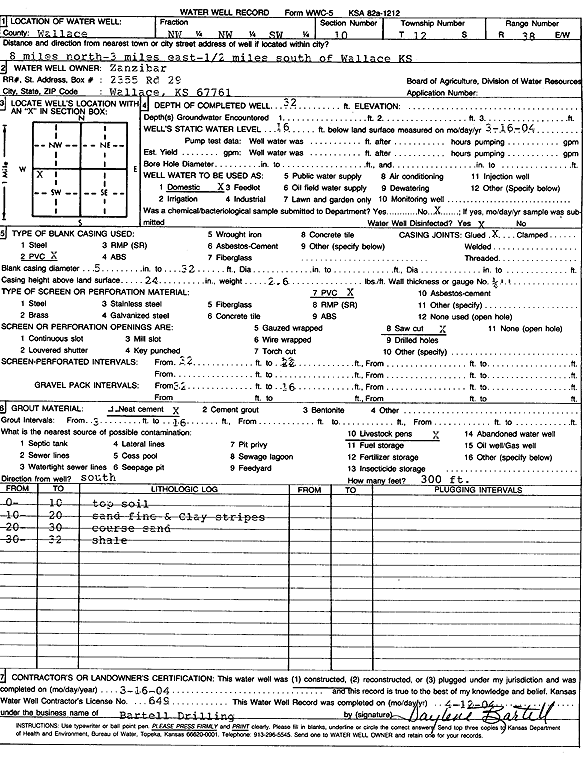
Specific Water Well Detail |
|
|
| Location Info | |||
| Owner: Zanzibar | Status: Constructed | ||
| Location: T12S, R38W, Sec. 10, NW NW SW | County: Wallace | ||
| Directions: from Wallace: 8 mi N, 3 mi E, .5 mi S | |||
| Latitude: 39.0254423 | Longitude: -101.53376 | Datum NAD 27 | |
| Latitude: 39.0254498 | Longitude: -101.5342038 | Datum NAD 83 | |
| Longitude and latitude calculated by Survey from township-range-section-quarter calls. Only good to within the quarter call accuracy. | |||
| View well on interactive map | |||
| General Info | ||
| Well Depth: 32 ft. | Elevation: ft. | |
| Static Water Level: 16 ft. | Est. Yield: gpm. | |
| Comp. Date: 16-Mar-2004 | Well Use: Domestic | |
| DWR Applic. #: | Other ID: | |
| Driller Info | ||
| Driller: Kyle R. Bartell Drlg. & Machine Works | License #: 649 | |
| Scanned Form | View scan |
|
Chemical Sample Submitted?:
Water Well disinfected?: | ||
| Casing Info | ||
| Casing Type:
Casing Joints: |
Diam: in. to ft | |
| Casing height above land surface: in
Casing Weight: lbs/ft Wall thickness or gauge no.: | ||
| Screen and Perforation Info | ||
| Screen Type: | Screen Openings: | |
| Screen-perforated intervals | From: ft to ft | |
| Gravel pack intervals | From: ft to ft | |
| Grout Info | ||
| Grout used: | From: to ft | |
| Source of Possible Contamination | ||
| Source: | ||
| Direction from well: | Distance: ft | |
| Lithologic Log
(Log data entered by KGS.) | ||
| From: 0 ft. to 10 ft. | Top soil | |
| From: 10 ft. to 20 ft. | Fine sand and clay stripes | |
| From: 20 ft. to 30 ft. | Coarse sand | |
| From: 30 ft. to 32 ft. | Shale | |