|
|
|
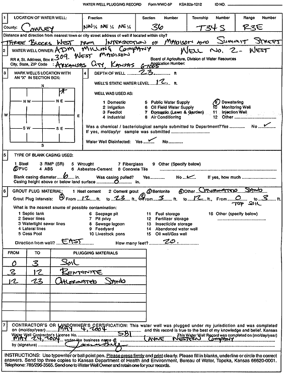
Specific Water Well Detail |
|
|
| Location Info | |||
| Owner: ADM Milling Company | Status: Plugged | ||
| Location: T34S, R3E, Sec. 36, NW NE NE | County: Cowley | ||
| Directions: from Madison and Summit St: 3 blks W | |||
| Latitude: 37.0554741 | Longitude: -97.0428072 | Datum NAD 27 | |
| Latitude: 37.0555033 | Longitude: -97.043123 | Datum NAD 83 | |
| Longitude and latitude calculated by Survey from township-range-section-quarter calls. Only good to within the quarter call accuracy. | |||
| View well on interactive map | |||
| General Info | ||
| Well Depth: 23 ft. | Elevation: ft. | |
| Static Water Level: 12 ft. | Est. Yield: gpm. | |
| Comp. Date: 04-May-2004 | Well Use: Dewatering | |
| DWR Applic. #: | Other ID: Well 2 W | |
| Driller Info | ||
| Driller: Layne Western | License #: 581 | |
| Scanned Form | View scan |
| Casing Info | ||
|
Casing Type:
Diam: in. Casing height above land surface: in | ||
| Grout Info | ||
| Grout used: | From: to ft | |
| Source of Possible Contamination | ||
| Source: | ||
| Direction from well: | Distance: ft | |