|
|
|
Specific Water Well Detail |
|
|
| Location Info | |||
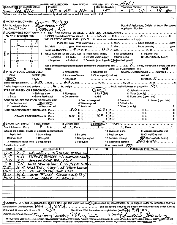
| Owner: ConocoPhillips | Status: Constructed | ||
| Location: T17S, R19E, Sec. 15, NE NE NE | County: Franklin | ||
| Directions: | |||
| Latitude: 38.5783897 | Longitude: -95.2873011 | Datum NAD 27 | |
| Latitude: 38.5784019 | Longitude: -95.2875533 | Datum NAD 83 | |
| Longitude and latitude calculated by Survey from township-range-section-quarter calls. Only good to within the quarter call accuracy. | |||
| View well on interactive map | |||
| General Info | ||
| Well Depth: 16 ft. | Elevation: ft. | |
| Static Water Level: 12 ft. | Est. Yield: gpm. | |
| Comp. Date: 09-Apr-2004 | Well Use: Monitoring well/observation/piezometer | |
| DWR Applic. #: | Other ID: MW 1 | |
| Driller Info | ||
| Driller: Audie L. Thornburg Contract Dewatering, Inc. | License #: 654 | |
| Scanned Form | View scan |
|
Chemical Sample Submitted?:
Water Well disinfected?: | ||
| Casing Info | ||
| Casing Type:
Casing Joints: |
Diam: in. to ft | |
| Casing height above land surface: in
Casing Weight: lbs/ft Wall thickness or gauge no.: | ||
| Screen and Perforation Info | ||
| Screen Type: | Screen Openings: | |
| Screen-perforated intervals | From: ft to ft | |
| Gravel pack intervals | From: ft to ft | |
| Grout Info | ||
| Grout used: | From: to ft | |
| Source of Possible Contamination | ||
| Source: | ||
| Direction from well: | Distance: ft | |
| Lithologic Log
(Log data entered by KGS.) | ||
| From: 0 ft. to 2.5 ft. | Wheat field with dark brown silty fat clay | |
| From: 2.5 ft. to 4 ft. | Dark brown silty fat clay with calcareous nodules | |
| From: 4 ft. to 5 ft. | Orange and gray brown clay | |
| From: 5 ft. to 7.5 ft. | Gray orange rust clay with rust nodules | |
| From: 7.5 ft. to 10.5 ft. | Gray rust olive clay with rust nodules | |
| From: 10.5 ft. to 12 ft. | Olive/gray fat clay | |
| From: 12 ft. to 15 ft. | Olive fat clay, crude oil at 13.5 ft | |
| From: 15 ft. to 16 ft. | Olive gray silty shale | |