|
|
|
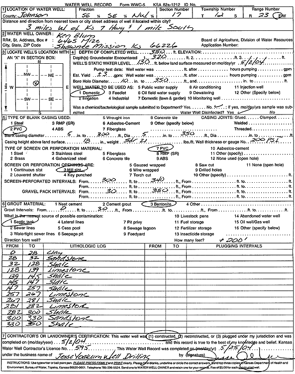
Specific Water Well Detail |
|
|
| Location Info | |||
| Owner: Blum, Ken | Status: Constructed | ||
| Location: T12S, R23E, Sec. 17, SE SE NW | County: Johnson | ||
| Directions: from K-7: 3 mi W, 1 mi S | |||
| Latitude: 39.0081204 | Longitude: -94.8825346 | Datum NAD 27 | |
| Latitude: 39.0081249 | Longitude: -94.8827771 | Datum NAD 83 | |
| Longitude and latitude calculated by Survey from township-range-section-quarter calls. Only good to within the quarter call accuracy. | |||
| View well on interactive map | |||
| General Info | ||
| Well Depth: 350 ft. | Elevation: ft. | |
| Static Water Level: 130 ft. | Est. Yield: 3 gpm. | |
| Comp. Date: 02-May-2004 | Well Use: Domestic | |
| DWR Applic. #: | Other ID: | |
| Driller Info | ||
| Driller: Jesse Yoakum Well Drilling | License #: 595 | |
| Scanned Form | View scan |
|
Chemical Sample Submitted?:
Water Well disinfected?: | ||
| Casing Info | ||
| Casing Type:
Casing Joints: |
Diam: in. to ft | |
| Casing height above land surface: in
Casing Weight: lbs/ft Wall thickness or gauge no.: | ||
| Screen and Perforation Info | ||
| Screen Type: | Screen Openings: | |
| Screen-perforated intervals | From: ft to ft | |
| Gravel pack intervals | From: ft to ft | |
| Grout Info | ||
| Grout used: | From: to ft | |
| Source of Possible Contamination | ||
| Source: | ||
| Direction from well: | Distance: ft | |
| Lithologic Log
(Log data entered by KGS.) | ||
| From: 0 ft. to 28 ft. | clay | |
| From: 28 ft. to 32 ft. | sandstone | |
| From: 32 ft. to 128 ft. | shale | |
| From: 128 ft. to 139 ft. | limestone | |
| From: 139 ft. to 145 ft. | shale | |
| From: 145 ft. to 147 ft. | slate | |
| From: 147 ft. to 257 ft. | shale | |
| From: 257 ft. to 267 ft. | limestone | |
| From: 267 ft. to 281 ft. | shale | |
| From: 281 ft. to 282 ft. | limestone | |
| From: 282 ft. to 300 ft. | shale | |
| From: 300 ft. to 330 ft. | sandstone | |
| From: 330 ft. to 350 ft. | shale | |