|
|
|
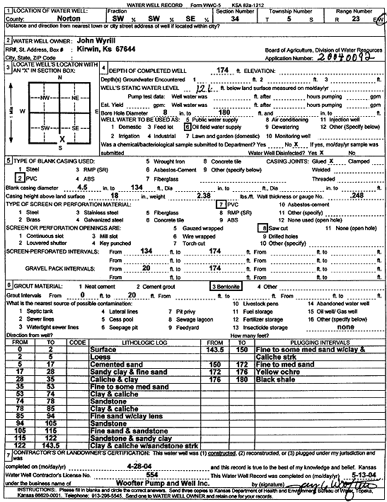
Specific Water Well Detail |
|
|
| Location Info | |||
| Owner: Wyrill, John | Status: Constructed | ||
| Location: T5S, R23W, Sec. 34, SW SW SE | County: Norton | ||
| Directions: | |||
| Latitude: 39.5677227 | Longitude: -99.8979012 | Datum NAD 27 | |
| Latitude: 39.5677277 | Longitude: -99.8983014 | Datum NAD 83 | |
| Longitude and latitude calculated by Survey from township-range-section-quarter calls. Only good to within the quarter call accuracy. | |||
| View well on interactive map | |||
| General Info | ||
| Well Depth: 174 ft. | Elevation: ft. | |
| Static Water Level: 126 ft. | Est. Yield: gpm. | |
| Comp. Date: 28-Apr-2004 | Well Use: Oil Field Water Supply | |
| DWR Applic. #: 20040092 | Other ID: | |
| Links | |
| No Wizard information available. | |
| View info from WIMAS Water Right Data base... | |
| Driller Info | ||
| Driller: Jay C. Woofter Pump & Well, Inc. | License #: 554 | |
| Scanned Form | View scan |
|
Chemical Sample Submitted?:
Water Well disinfected?: | ||
| Casing Info | ||
| Casing Type:
Casing Joints: |
Diam: in. to ft | |
| Casing height above land surface: in
Casing Weight: lbs/ft Wall thickness or gauge no.: | ||
| Screen and Perforation Info | ||
| Screen Type: | Screen Openings: | |
| Screen-perforated intervals | From: ft to ft | |
| Gravel pack intervals | From: ft to ft | |
| Grout Info | ||
| Grout used: | From: to ft | |
| Source of Possible Contamination | ||
| Source: | ||
| Direction from well: | Distance: ft | |
| Lithologic Log
(Log data entered by KGS.) | ||
| From: 0 ft. to 2 ft. | surface | |
| From: 2 ft. to 5 ft. | cemented sand | |
| From: 5 ft. to 17 ft. | cemented sand | |
| From: 17 ft. to 28 ft. | sandy clay and fine sand | |
| From: 28 ft. to 35 ft. | caliche and clay | |
| From: 35 ft. to 53 ft. | fine to some medium sand | |
| From: 53 ft. to 74 ft. | clay and caliche | |
| From: 74 ft. to 78 ft. | sandstone | |
| From: 78 ft. to 85 ft. | clay and caliche | |
| From: 85 ft. to 94 ft. | fine sand with clay lens | |
| From: 94 ft. to 105 ft. | sandstone | |
| From: 105 ft. to 115 ft. | fine sand and sandstone | |
| From: 115 ft. to 122 ft. | sandstone and sandy clay | |
| From: 122 ft. to 143.5 ft. | clay and caliche with sandstone streak | |
| From: 143.5 ft. to 150 ft. | fine to some medium sand with clay and caliche streak | |
| From: 150 ft. to 172 ft. | fine to medium sand | |
| From: 172 ft. to 176 ft. | yellow ochre | |
| From: 176 ft. to 180 ft. | black shale | |