|
|
|
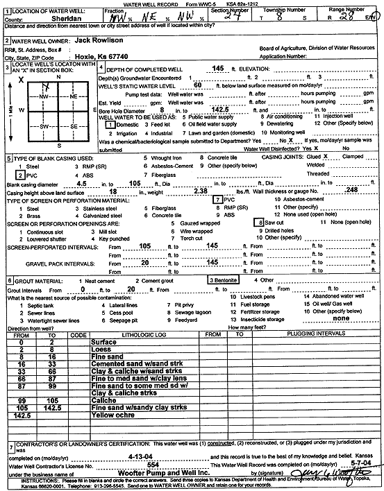
Specific Water Well Detail |
|
|
| Location Info | |||
| Owner: Rowlison, Jack | Status: Constructed | ||
| Location: T8S, R28W, Sec. 24, NW NE NW | County: Sheridan | ||
| Directions: | |||
| Latitude: 39.3496627 | Longitude: -100.3987659 | Datum NAD 27 | |
| Latitude: 39.3496675 | Longitude: -100.399183 | Datum NAD 83 | |
| Longitude and latitude calculated by Survey from township-range-section-quarter calls. Only good to within the quarter call accuracy. | |||
| View well on interactive map | |||
| General Info | ||
| Well Depth: 145 ft. | Elevation: ft. | |
| Static Water Level: 60 ft. | Est. Yield: gpm. | |
| Comp. Date: 13-Apr-2004 | Well Use: Domestic | |
| DWR Applic. #: | Other ID: | |
| Driller Info | ||
| Driller: Jay C. Woofter Pump & Well, Inc. | License #: 554 | |
| Scanned Form | View scan |
|
Chemical Sample Submitted?:
Water Well disinfected?: | ||
| Casing Info | ||
| Casing Type:
Casing Joints: |
Diam: in. to ft | |
| Casing height above land surface: in
Casing Weight: lbs/ft Wall thickness or gauge no.: | ||
| Screen and Perforation Info | ||
| Screen Type: | Screen Openings: | |
| Screen-perforated intervals | From: ft to ft | |
| Gravel pack intervals | From: ft to ft | |
| Grout Info | ||
| Grout used: | From: to ft | |
| Source of Possible Contamination | ||
| Source: | ||
| Direction from well: | Distance: ft | |
| Lithologic Log
(Log data entered by KGS.) | ||
| From: 0 ft. to 2 ft. | Surface | |
| From: 2 ft. to 8 ft. | Loess | |
| From: 8 ft. to 16 ft. | Fine sand | |
| From: 16 ft. to 33 ft. | Cemented sand with sand streak | |
| From: 33 ft. to 66 ft. | Clay and caliche with sand streaks | |
| From: 66 ft. to 87 ft. | Fine to medium sand with clay lens | |
| From: 87 ft. to 99 ft. | Fine sand to some medium sand with clay and caliche streaks | |
| From: 99 ft. to 105 ft. | Caliche | |
| From: 105 ft. to 142.5 ft. | Fine sand with sandy clay streaks | |
| From: 142.5 ft. to ft. | Yellow ochre | |