|
|
|
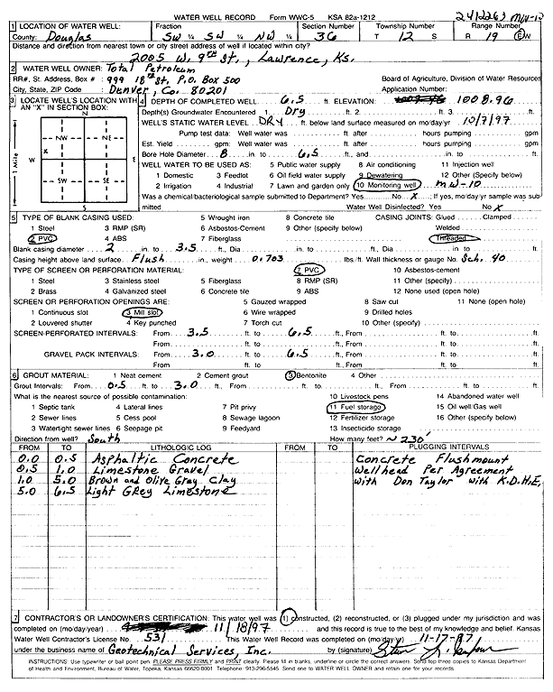
Specific Water Well Detail |
|
|
| Location Info | |||
| Owner: Total Petroleum Inc. | Status: Constructed | ||
| Location: T12S, R19E, Sec. 36, SW SW NW | County: Douglas | ||
| Directions: 2005 W 9th, Lawrence (id 2412263) | |||
| Latitude: 38.9651343 | Longitude: -95.2589394 | Datum NAD 27 | |
| Latitude: 38.9651365 | Longitude: -95.25919 | Datum NAD 83 | |
| Longitude and latitude calculated by Survey from township-range-section-quarter calls. Only good to within the quarter call accuracy. | |||
| View well on interactive map | |||
| General Info | ||
| Well Depth: 6.5 ft. | Elevation: 1008.96 ft. | |
| Static Water Level: ft. | Est. Yield: gpm. | |
| Comp. Date: 18-Nov-1997 | Well Use: Monitoring well/observation/piezometer | |
| DWR Applic. #: | Other ID: MW 10 | |
| Driller Info | ||
| Driller: Geotechnical Services, Inc. | License #: 531 | |
| Scanned Form | View scan |
|
Chemical Sample Submitted?:
Water Well disinfected?: | ||
| Casing Info | ||
| Casing Type:
Casing Joints: |
Diam: in. to ft | |
| Casing height above land surface: in
Casing Weight: lbs/ft Wall thickness or gauge no.: | ||
| Screen and Perforation Info | ||
| Screen Type: | Screen Openings: | |
| Screen-perforated intervals | From: ft to ft | |
| Gravel pack intervals | From: ft to ft | |
| Grout Info | ||
| Grout used: | From: to ft | |
| Source of Possible Contamination | ||
| Source: | ||
| Direction from well: | Distance: ft | |
| Lithologic Log
(Log data entered by KGS.) | ||
| From: 0 ft. to .5 ft. | asphalt and concrete | |
| From: .5 ft. to 1 ft. | limestone gravel | |
| From: 1 ft. to 5 ft. | brown and olive gray clay | |
| From: 5 ft. to 6.5 ft. | light gray limestone | |