|
|
|
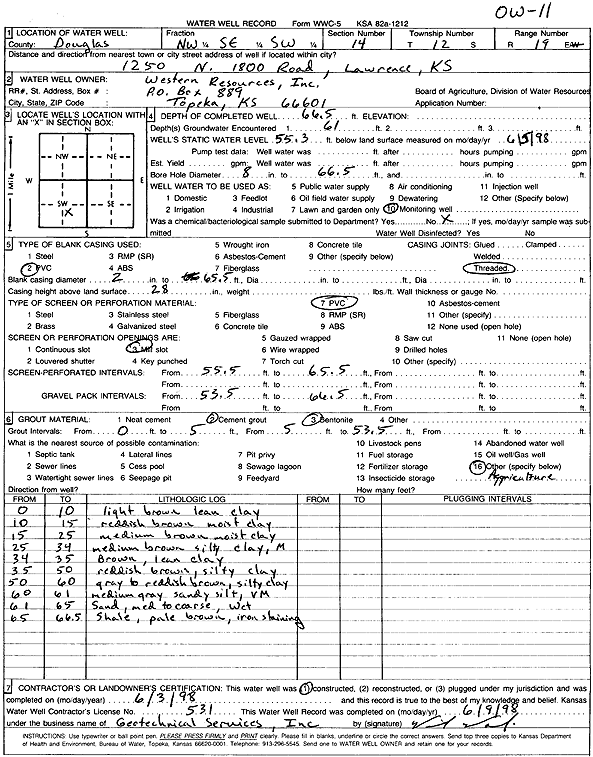
Specific Water Well Detail |
|
|
| Location Info | |||
| Owner: Western Resources | Status: Constructed | ||
| Location: T12S, R19E, Sec. 14, NW SE SW | County: Douglas | ||
| Directions: 1250 N 1800 Rd, Lawrence | |||
| Latitude: 39.0033488 | Longitude: -95.2731148 | Datum NAD 27 | |
| Latitude: 39.0033501 | Longitude: -95.2733655 | Datum NAD 83 | |
| Longitude and latitude calculated by Survey from township-range-section-quarter calls. Only good to within the quarter call accuracy. | |||
| View well on interactive map | |||
| General Info | ||
| Well Depth: 66.5 ft. | Elevation: ft. | |
| Static Water Level: 55.3 ft. | Est. Yield: gpm. | |
| Comp. Date: 03-Jun-1998 | Well Use: Monitoring well/observation/piezometer | |
| DWR Applic. #: | Other ID: OW 11 | |
| Driller Info | ||
| Driller: Geotechnical Services, Inc. | License #: 531 | |
| Scanned Form | View scan |
|
Chemical Sample Submitted?:
Water Well disinfected?: | ||
| Casing Info | ||
| Casing Type:
Casing Joints: |
Diam: in. to ft | |
| Casing height above land surface: in
Casing Weight: lbs/ft Wall thickness or gauge no.: | ||
| Screen and Perforation Info | ||
| Screen Type: | Screen Openings: | |
| Screen-perforated intervals | From: ft to ft | |
| Gravel pack intervals | From: ft to ft | |
| Grout Info | ||
| Grout used: | From: to ft | |
| Source of Possible Contamination | ||
| Source: | ||
| Direction from well: | Distance: ft | |
| Lithologic Log
(Log data entered by KGS.) | ||
| From: 0 ft. to 10 ft. | light brown lean clay | |
| From: 10 ft. to 15 ft. | reddish brown clay, moist | |
| From: 15 ft. to 25 ft. | medium brown clay, moist | |
| From: 25 ft. to 34 ft. | medium brown silty clay, moist | |
| From: 34 ft. to 35 ft. | brown lean clay | |
| From: 35 ft. to 50 ft. | reddish brown silty clay | |
| From: 50 ft. to 60 ft. | gray to reddish brown silty clay | |
| From: 60 ft. to 61 ft. | medium sand sandy silt, very moist | |
| From: 61 ft. to 65 ft. | medium to coarse sand, wet | |
| From: 65 ft. to 66.5 ft. | shale, pale brown with iron staining | |