|
|
|
Specific Water Well Detail |
|
|
| Location Info | |||
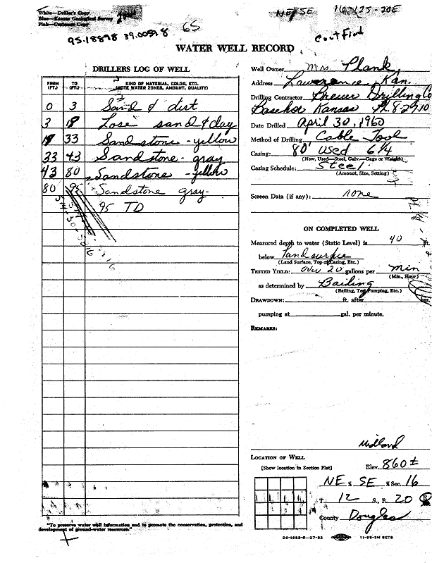
| Owner: Plank, Mrs. | Status: Constructed | ||
| Location: T12S, R20E, Sec. 16, NE SE | County: Douglas | ||
| Directions: Lawrence | |||
| Latitude: 39.0059779 | Longitude: -95.1889784 | Datum NAD 27 | |
| Latitude: 39.0059797 | Longitude: -95.1892277 | Datum NAD 83 | |
| Longitude and latitude calculated by Survey from township-range-section-quarter calls. Only good to within the quarter call accuracy. | |||
| View well on interactive map | |||
| General Info | ||
| Well Depth: 95 ft. | Elevation: 860 ft. | |
| Static Water Level: 40 ft. | Est. Yield: 20 gpm. | |
| Comp. Date: 30-Apr-1960 | Well Use: Domestic | |
| DWR Applic. #: | Other ID: | |
| Driller Info | ||
| Driller: Breuer Drilling Co. | License #: | |
| Scanned Form | View scan |
|
Chemical Sample Submitted?:
Water Well disinfected?: | ||
| Casing Info | ||
| Casing Type:
Casing Joints: |
Diam: in. to ft | |
| Casing height above land surface: in
Casing Weight: lbs/ft Wall thickness or gauge no.: | ||
| Screen and Perforation Info | ||
| Screen Type: | Screen Openings: | |
| Screen-perforated intervals | From: ft to ft | |
| Gravel pack intervals | From: ft to ft | |
| Grout Info | ||
| Grout used: | From: to ft | |
| Source of Possible Contamination | ||
| Source: | ||
| Direction from well: | Distance: ft | |
| Lithologic Log
(Log data entered by KGS.) | ||
| From: 0 ft. to 3 ft. | sand and dirt | |
| From: 3 ft. to 19 ft. | loose sand and clay | |
| From: 19 ft. to 33 ft. | sandstone, yellow | |
| From: 33 ft. to 43 ft. | sandstone, gray | |
| From: 43 ft. to 80 ft. | sandstone, yellow | |
| From: 80 ft. to 95 ft. | sandstone, gray | |