|
|
|
Specific Water Well Detail |
|
|
| Location Info | |||
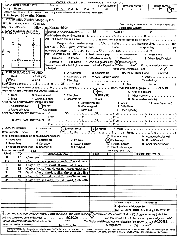
| Owner: Kloepper, Inc. | Status: Constructed | ||
| Location: T2S, R17E, Sec. 28, SW NW NW | County: Brown | ||
| Directions: 100 Oregon, Hiawatha | |||
| Latitude: 39.8532401 | Longitude: -95.5257526 | Datum NAD 27 | |
| Latitude: 39.8532436 | Longitude: -95.5260125 | Datum NAD 83 | |
| Longitude and latitude calculated by Survey from township-range-section-quarter calls. Only good to within the quarter call accuracy. | |||
| View well on interactive map | |||
| General Info | ||
| Well Depth: 55 ft. | Elevation: ft. | |
| Static Water Level: ft. | Est. Yield: gpm. | |
| Comp. Date: 24-May-2004 | Well Use: Monitoring well/observation/piezometer | |
| DWR Applic. #: | Other ID: MW 5R | |
| Driller Info | ||
| Driller: GeoCore Services Inc. | License #: 527 | |
| Scanned Form | View scan |
|
Chemical Sample Submitted?:
Water Well disinfected?: | ||
| Casing Info | ||
| Casing Type:
Casing Joints: |
Diam: in. to ft | |
| Casing height above land surface: in
Casing Weight: lbs/ft Wall thickness or gauge no.: | ||
| Screen and Perforation Info | ||
| Screen Type: | Screen Openings: | |
| Screen-perforated intervals | From: ft to ft | |
| Gravel pack intervals | From: ft to ft | |
| Grout Info | ||
| Grout used: | From: to ft | |
| Source of Possible Contamination | ||
| Source: | ||
| Direction from well: | Distance: ft | |
| Lithologic Log
(Log data entered by KGS.) | ||
| From: 0 ft. to .5 ft. | Concrete | |
| From: .5 ft. to 11 ft. | Clay very silty, very plastic, very moist, dark green | |
| From: 11 ft. to 18 ft. | Clay, silty, firm, moist, brown mottled black | |
| From: 18 ft. to 33 ft. | Clay, silty, very firm, slightly moist, brown mottled green | |
| From: 33 ft. to 37 ft. | Sand, very fine-medium, very silty, clayey, moist, brown | |
| From: 37 ft. to 49 ft. | Clay, silty, firm, slightly moist, brown/green mottled | |
| From: 49 ft. to 55 ft. | Clay, silty, slightly sandy, firm, slightly moist, yellow/brown | |