|
|
|
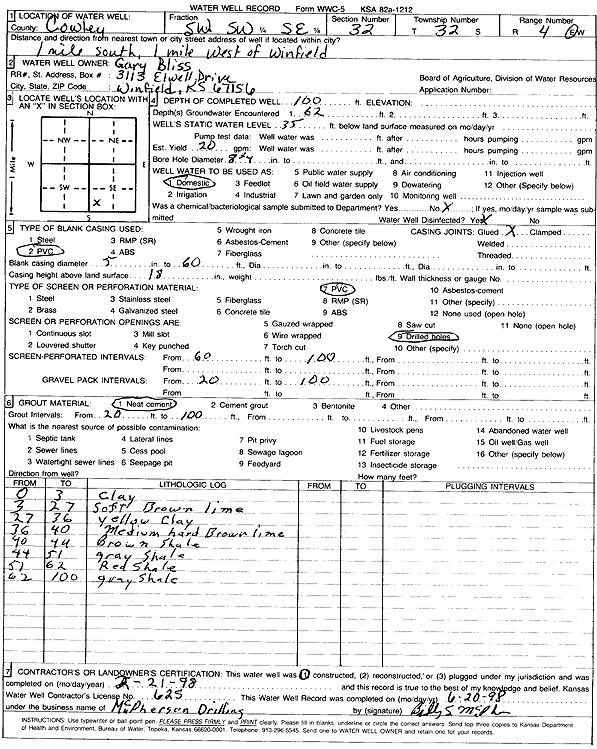
Specific Water Well Detail |
|
|
| Location Info | |||
| Owner: Bliss, Gary | Status: Constructed | ||
| Location: T32S, R4E, Sec. 32, SW SW SE | County: Cowley | ||
| Directions: from Winfield: 1 mi S, 1 mi W | |||
| Latitude: 37.2167436 | Longitude: -97.0127575 | Datum NAD 27 | |
| Latitude: 37.2167703 | Longitude: -97.0130722 | Datum NAD 83 | |
| Longitude and latitude calculated by Survey from township-range-section-quarter calls. Only good to within the quarter call accuracy. | |||
| View well on interactive map | |||
| General Info | ||
| Well Depth: 100 ft. | Elevation: ft. | |
| Static Water Level: 35 ft. | Est. Yield: 20 gpm. | |
| Comp. Date: 21-Feb-1998 | Well Use: Domestic | |
| DWR Applic. #: | Other ID: | |
| Driller Info | ||
| Driller: Billy McPherson Drilling Co. | License #: 625 | |
| Scanned Form | View scan |
|
Chemical Sample Submitted?:
Water Well disinfected?: | ||
| Casing Info | ||
| Casing Type:
Casing Joints: |
Diam: in. to ft | |
| Casing height above land surface: in
Casing Weight: lbs/ft Wall thickness or gauge no.: | ||
| Screen and Perforation Info | ||
| Screen Type: | Screen Openings: | |
| Screen-perforated intervals | From: ft to ft | |
| Gravel pack intervals | From: ft to ft | |
| Grout Info | ||
| Grout used: | From: to ft | |
| Source of Possible Contamination | ||
| Source: | ||
| Direction from well: | Distance: ft | |
| Lithologic Log
(Log data entered by KGS.) | ||
| From: 0 ft. to 3 ft. | clay | |
| From: 3 ft. to 27 ft. | soft brown limestone | |
| From: 27 ft. to 36 ft. | yellow clay | |
| From: 36 ft. to 40 ft. | medium hard brown sandstone | |
| From: 40 ft. to 44 ft. | brown shale | |
| From: 44 ft. to 51 ft. | gray shale | |
| From: 51 ft. to 62 ft. | red shale | |
| From: 62 ft. to 100 ft. | gray shale | |