|
|
|
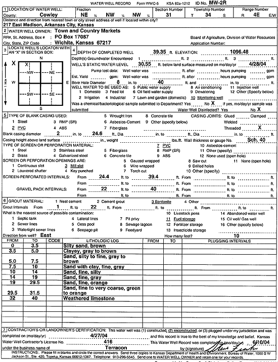
Specific Water Well Detail |
|
|
| Location Info | |||
| Owner: Town and Country Markets | Status: Reconstructed | ||
| Location: T34S, R4E, Sec. 31, NE NW NW | County: Cowley | ||
| Directions: 217 E Madison, Arkansas City | |||
| Latitude: 37.055434 | Longitude: -97.0361545 | Datum NAD 27 | |
| Latitude: 37.0554632 | Longitude: -97.0364702 | Datum NAD 83 | |
| Longitude and latitude calculated by Survey from township-range-section-quarter calls. Only good to within the quarter call accuracy. | |||
| View well on interactive map | |||
| General Info | ||
| Well Depth: 39.35 ft. | Elevation: 1096.48 ft. | |
| Static Water Level: 30.55 ft. | Est. Yield: gpm. | |
| Comp. Date: 27-Apr-2004 | Well Use: Monitoring well/observation/piezometer | |
| DWR Applic. #: | Other ID: MW 2 R | |
| Driller Info | ||
| Driller: Terracon, Inc. | License #: 416 | |
| Scanned Form | View scan |
|
Chemical Sample Submitted?:
Water Well disinfected?: | ||
| Casing Info | ||
| Casing Type:
Casing Joints: |
Diam: in. to ft | |
| Casing height above land surface: in
Casing Weight: lbs/ft Wall thickness or gauge no.: | ||
| Screen and Perforation Info | ||
| Screen Type: | Screen Openings: | |
| Screen-perforated intervals | From: ft to ft | |
| Gravel pack intervals | From: ft to ft | |
| Grout Info | ||
| Grout used: | From: to ft | |
| Source of Possible Contamination | ||
| Source: | ||
| Direction from well: | Distance: ft | |