|
|
|
Specific Water Well Detail |
|
|
| Location Info | |||
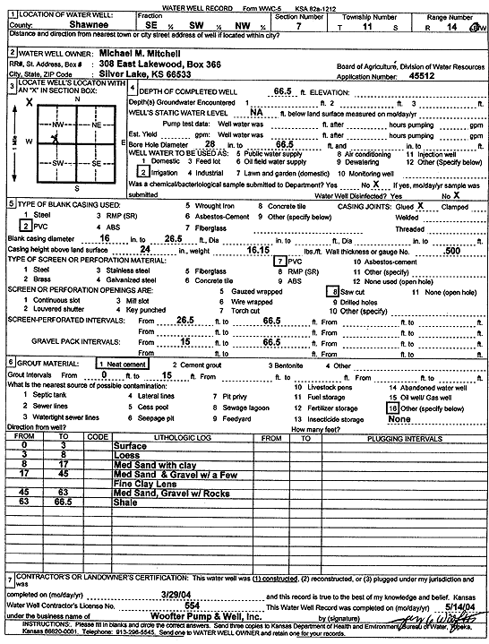
| Owner: Mitchell, Michael M. | Status: Constructed | ||
| Location: T11S, R14E, Sec. 7, SE SW NW | County: Shawnee | ||
| Directions: | |||
| Latitude: 39.1097603 | Longitude: -95.9060239 | Datum NAD 27 | |
| Latitude: 39.1097594 | Longitude: -95.9062898 | Datum NAD 83 | |
| Longitude and latitude calculated by Survey from township-range-section-quarter calls. Only good to within the quarter call accuracy. | |||
| View well on interactive map | |||
| General Info | ||
| Well Depth: 66.5 ft. | Elevation: ft. | |
| Static Water Level: ft. | Est. Yield: gpm. | |
| Comp. Date: 29-Mar-2004 | Well Use: Irrigation | |
| DWR Applic. #: 45512 | Other ID: | |
| Links | |
| No Wizard information available. | |
| View info from WIMAS Water Right Data base... | |
| Driller Info | ||
| Driller: Jay C. Woofter Pump & Well, Inc. | License #: 554 | |
| Scanned Form | View scan |
|
Chemical Sample Submitted?:
Water Well disinfected?: | ||
| Casing Info | ||
| Casing Type:
Casing Joints: |
Diam: in. to ft | |
| Casing height above land surface: in
Casing Weight: lbs/ft Wall thickness or gauge no.: | ||
| Screen and Perforation Info | ||
| Screen Type: | Screen Openings: | |
| Screen-perforated intervals | From: ft to ft | |
| Gravel pack intervals | From: ft to ft | |
| Grout Info | ||
| Grout used: | From: to ft | |
| Source of Possible Contamination | ||
| Source: | ||
| Direction from well: | Distance: ft | |
| Lithologic Log
(Log data entered by KGS.) | ||
| From: 0 ft. to 3 ft. | surface | |
| From: 3 ft. to 8 ft. | loess | |
| From: 8 ft. to 17 ft. | medium sand with clay | |
| From: 17 ft. to 45 ft. | medium sand and gravel with a few fine clay lenses | |
| From: 45 ft. to 63 ft. | medium sand and gravel with rocks | |
| From: 63 ft. to 66.5 ft. | shale | |