|
|
|
Specific Water Well Detail |
|
|
| Location Info | |||
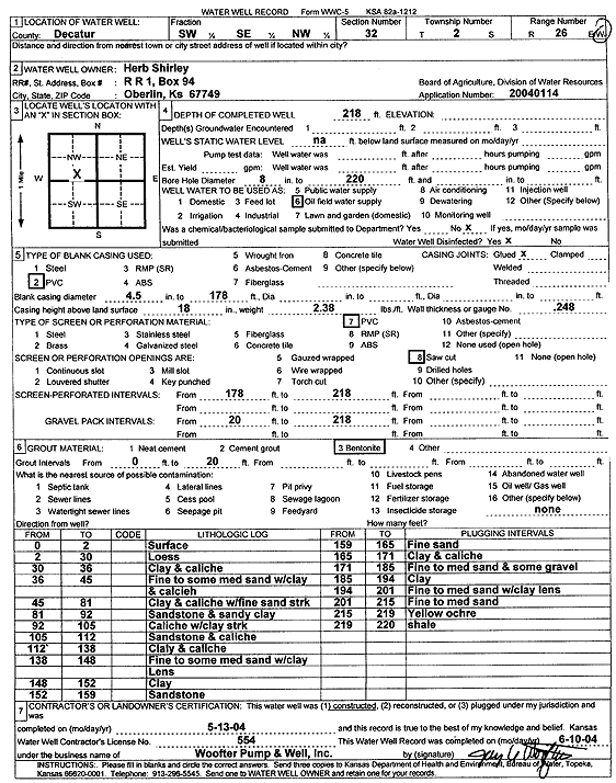
| Owner: Shirley, Herb | Status: Constructed | ||
| Location: T2S, R26W, Sec. 32, SW SE NW | County: Decatur | ||
| Directions: | |||
| Latitude: 39.8361023 | Longitude: -100.2671768 | Datum NAD 27 | |
| Latitude: 39.8361072 | Longitude: -100.267594 | Datum NAD 83 | |
| Longitude and latitude calculated by Survey from township-range-section-quarter calls. Only good to within the quarter call accuracy. | |||
| View well on interactive map | |||
| General Info | ||
| Well Depth: 218 ft. | Elevation: ft. | |
| Static Water Level: ft. | Est. Yield: gpm. | |
| Comp. Date: 13-May-2004 | Well Use: Oil Field Water Supply | |
| DWR Applic. #: 20040114 | Other ID: | |
| Links | |
| No Wizard information available. | |
| View info from WIMAS Water Right Data base... | |
| Driller Info | ||
| Driller: Jay C. Woofter Pump & Well, Inc. | License #: 554 | |
| Scanned Form | View scan |
|
Chemical Sample Submitted?:
Water Well disinfected?: | ||
| Casing Info | ||
| Casing Type:
Casing Joints: |
Diam: in. to ft | |
| Casing height above land surface: in
Casing Weight: lbs/ft Wall thickness or gauge no.: | ||
| Screen and Perforation Info | ||
| Screen Type: | Screen Openings: | |
| Screen-perforated intervals | From: ft to ft | |
| Gravel pack intervals | From: ft to ft | |
| Grout Info | ||
| Grout used: | From: to ft | |
| Source of Possible Contamination | ||
| Source: | ||
| Direction from well: | Distance: ft | |
| Lithologic Log
(Log data entered by KGS.) | ||
| From: 0 ft. to 2 ft. | surface | |
| From: 2 ft. to 30 ft. | loess | |
| From: 30 ft. to 36 ft. | clay and caliche | |
| From: 36 ft. to 45 ft. | fine to some medium sand with clay and caliche | |
| From: 45 ft. to 81 ft. | clay and caliche with fine sand streaks | |
| From: 81 ft. to 92 ft. | sandstone and sandy clay | |
| From: 92 ft. to 105 ft. | caliche with clay streak | |
| From: 105 ft. to 112 ft. | sandstone and caliche | |
| From: 112 ft. to 138 ft. | clay and caliche | |
| From: 138 ft. to 148 ft. | fine to some medium sand with clay lens | |
| From: 148 ft. to 152 ft. | clay | |
| From: 152 ft. to 159 ft. | sandstone | |
| From: 159 ft. to 165 ft. | fine sand | |
| From: 165 ft. to 171 ft. | clay and caliche | |
| From: 171 ft. to 185 ft. | fine to medium sand and some gravel | |
| From: 185 ft. to 194 ft. | clay | |
| From: 194 ft. to 201 ft. | fine to medium sand with clay lens | |
| From: 201 ft. to 215 ft. | fine to medium sand | |
| From: 215 ft. to 219 ft. | yellow ochre | |
| From: 219 ft. to 220 ft. | shale | |