|
|
|
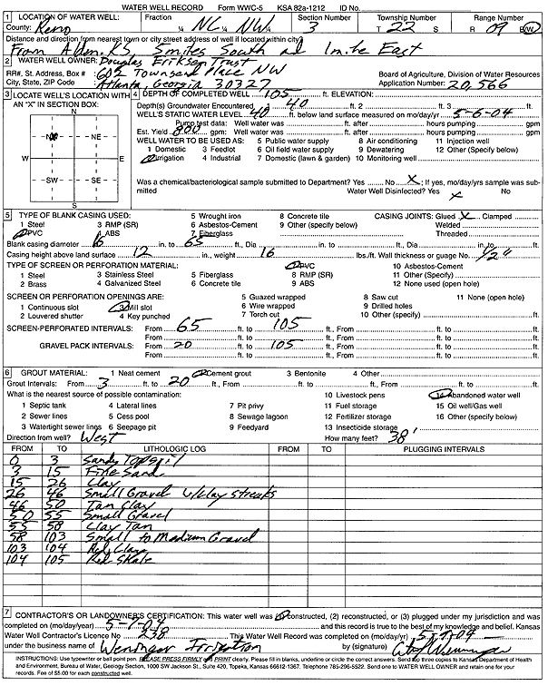
Specific Water Well Detail |
|
|
| Location Info | |||
| Owner: Douglas Eriksen Trust | Status: Constructed | ||
| Location: T22S, R9W, Sec. 3, C NW | County: Reno | ||
| Directions: from Alden: 5 mi S, 1 mi E | |||
| Latitude: 38.1698656 | Longitude: -98.3024377 | Datum NAD 27 | |
| Latitude: 38.1698777 | Longitude: -98.3027816 | Datum NAD 83 | |
| Longitude and latitude calculated by Survey from township-range-section-quarter calls. Only good to within the quarter call accuracy. | |||
| View well on interactive map | |||
| General Info | ||
| Well Depth: 105 ft. | Elevation: ft. | |
| Static Water Level: 40 ft. | Est. Yield: 800 gpm. | |
| Comp. Date: 07-May-2004 | Well Use: Irrigation | |
| DWR Applic. #: 20566 | Other ID: | |
| Links | |
| No Wizard information available. | |
| View info from WIMAS Water Right Data base... | |
| Driller Info | ||
| Driller: Curtis J. Weninger Irrigation | License #: 238 | |
| Scanned Form | View scan |
|
Chemical Sample Submitted?:
Water Well disinfected?: | ||
| Casing Info | ||
| Casing Type:
Casing Joints: |
Diam: in. to ft | |
| Casing height above land surface: in
Casing Weight: lbs/ft Wall thickness or gauge no.: | ||
| Screen and Perforation Info | ||
| Screen Type: | Screen Openings: | |
| Screen-perforated intervals | From: ft to ft | |
| Gravel pack intervals | From: ft to ft | |
| Grout Info | ||
| Grout used: | From: to ft | |
| Source of Possible Contamination | ||
| Source: | ||
| Direction from well: | Distance: ft | |
| Lithologic Log
(Log data entered by KGS.) | ||
| From: 0 ft. to 3 ft. | sandy top soil | |
| From: 3 ft. to 15 ft. | fine sand | |
| From: 15 ft. to 26 ft. | clay | |
| From: 26 ft. to 46 ft. | small gravel with clay streaks | |
| From: 46 ft. to 50 ft. | tan clay | |
| From: 50 ft. to 55 ft. | small gravel | |
| From: 55 ft. to 58 ft. | clay, tan | |
| From: 58 ft. to 103 ft. | small to medium gravel | |
| From: 103 ft. to 104 ft. | red clay | |
| From: 104 ft. to 105 ft. | red shale | |