|
|
|
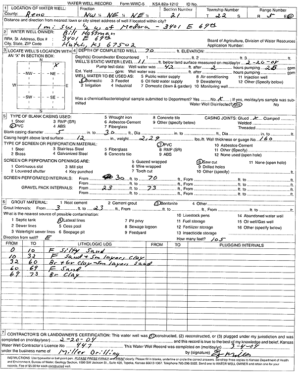
Specific Water Well Detail |
|
|
| Location Info | |||
| Owner: Hoffman, Bill | Status: Constructed | ||
| Location: T22S, R5W, Sec. 21, NW NE NE | County: Reno | ||
| Directions: 3401 E 69th, Hutchinson - from Medora: 1 mi SW, 0.5 mi W | |||
| Latitude: 38.1293294 | Longitude: -97.8700565 | Datum NAD 27 | |
| Latitude: 38.12934 | Longitude: -97.8703846 | Datum NAD 83 | |
| Longitude and latitude calculated by Survey from township-range-section-quarter calls. Only good to within the quarter call accuracy. | |||
| View well on interactive map | |||
| General Info | ||
| Well Depth: 70 ft. | Elevation: ft. | |
| Static Water Level: 11 ft. | Est. Yield: gpm. | |
| Comp. Date: 20-Feb-2004 | Well Use: Domestic | |
| DWR Applic. #: | Other ID: | |
| Driller Info | ||
| Driller: Miller Drilling | License #: 447 | |
| Scanned Form | View scan |
|
Chemical Sample Submitted?:
Water Well disinfected?: | ||
| Casing Info | ||
| Casing Type:
Casing Joints: |
Diam: in. to ft | |
| Casing height above land surface: in
Casing Weight: lbs/ft Wall thickness or gauge no.: | ||
| Screen and Perforation Info | ||
| Screen Type: | Screen Openings: | |
| Screen-perforated intervals | From: ft to ft | |
| Gravel pack intervals | From: ft to ft | |
| Grout Info | ||
| Grout used: | From: to ft | |
| Source of Possible Contamination | ||
| Source: | ||
| Direction from well: | Distance: ft | |
| Lithologic Log
(Log data entered by KGS.) | ||
| From: 0 ft. to 10 ft. | fine silty sand | |
| From: 10 ft. to 32 ft. | fine sand with small layers of clay | |
| From: 32 ft. to 60 ft. | brown and gray clay with small layers of sand | |
| From: 60 ft. to 69 ft. | fine sand | |
| From: 69 ft. to 73 ft. | brown clay | |