|
|
|
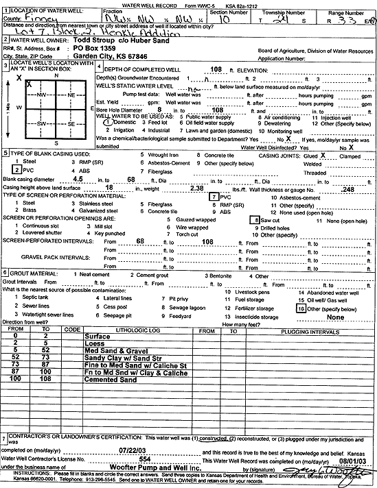
Specific Water Well Detail |
|
|
| Location Info | |||
| Owner: Todd Stroup/Huber Sand | Status: Constructed | ||
| Location: T24S, R33W, Sec. 10, NW NW NW | County: Finney | ||
| Directions: Lot 7, Blk 2, Henkle Addition | |||
| Latitude: 37.9883196 | Longitude: -100.9370033 | Datum NAD 27 | |
| Latitude: 37.9883433 | Longitude: -100.9374453 | Datum NAD 83 | |
| Longitude and latitude calculated by Survey from township-range-section-quarter calls. Only good to within the quarter call accuracy. | |||
| View well on interactive map | |||
| General Info | ||
| Well Depth: 108 ft. | Elevation: ft. | |
| Static Water Level: ft. | Est. Yield: gpm. | |
| Comp. Date: 22-Jul-2003 | Well Use: Domestic | |
| DWR Applic. #: | Other ID: | |
| Driller Info | ||
| Driller: Jay C. Woofter Pump & Well, Inc. | License #: 554 | |
| Scanned Form | View scan |
|
Chemical Sample Submitted?:
Water Well disinfected?: | ||
| Casing Info | ||
| Casing Type:
Casing Joints: |
Diam: in. to ft | |
| Casing height above land surface: in
Casing Weight: lbs/ft Wall thickness or gauge no.: | ||
| Screen and Perforation Info | ||
| Screen Type: | Screen Openings: | |
| Screen-perforated intervals | From: ft to ft | |
| Gravel pack intervals | From: ft to ft | |
| Grout Info | ||
| Grout used: | From: to ft | |
| Source of Possible Contamination | ||
| Source: | ||
| Direction from well: | Distance: ft | |
| Lithologic Log
(Log data entered by KGS.) | ||
| From: 0 ft. to 2 ft. | surface | |
| From: 2 ft. to 5 ft. | loess | |
| From: 5 ft. to 52 ft. | medium sand and gravel | |
| From: 52 ft. to 73 ft. | sandy clay with sand streaks | |
| From: 73 ft. to 87 ft. | fine to medium sand with caliche streaks | |
| From: 87 ft. to 100 ft. | fine to medium sand with clay and caliche | |
| From: 100 ft. to 108 ft. | cemented sand | |