|
|
|
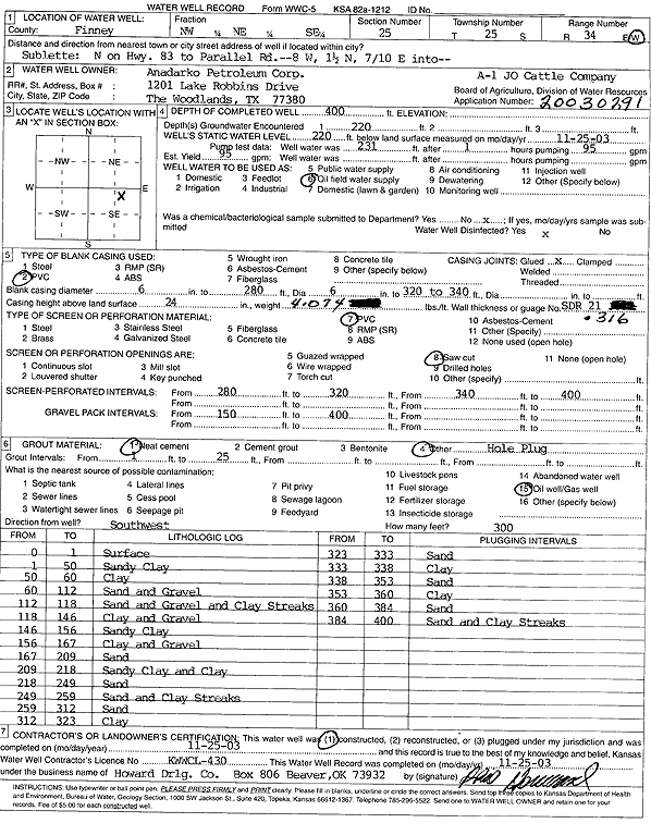
Specific Water Well Detail |
|
|
| Location Info | |||
| Owner: Anadarko Petroleum Corp. | Status: Constructed | ||
| Location: T25S, R34W, Sec. 25, NW NE SE | County: Finney | ||
| Directions: from Sublette: N on Hwy 83 to Parallel Rd, 8 mi W, 1.5 mi N, 0.7 mi E into site | |||
| Latitude: 37.850344 | Longitude: -100.9962465 | Datum NAD 27 | |
| Latitude: 37.8503679 | Longitude: -100.9966922 | Datum NAD 83 | |
| Longitude and latitude calculated by Survey from township-range-section-quarter calls. Only good to within the quarter call accuracy. | |||
| View well on interactive map | |||
| General Info | ||
| Well Depth: 400 ft. | Elevation: ft. | |
| Static Water Level: 220 ft. | Est. Yield: 95 gpm. | |
| Comp. Date: 25-Nov-2003 | Well Use: Oil Field Water Supply | |
| DWR Applic. #: 20030291 | Other ID: J.O. Cattle Co. A-1 | |
| Links | |
| No Wizard information available. | |
| View info from WIMAS Water Right Data base... | |
| Driller Info | ||
| Driller: Howard Drilling Company AG, LLC | License #: 430 | |
| Scanned Form | View scan |
|
Chemical Sample Submitted?:
Water Well disinfected?: | ||
| Casing Info | ||
| Casing Type:
Casing Joints: |
Diam: in. to ft | |
| Casing height above land surface: in
Casing Weight: lbs/ft Wall thickness or gauge no.: | ||
| Screen and Perforation Info | ||
| Screen Type: | Screen Openings: | |
| Screen-perforated intervals | From: ft to ft | |
| Gravel pack intervals | From: ft to ft | |
| Grout Info | ||
| Grout used: | From: to ft | |
| Source of Possible Contamination | ||
| Source: | ||
| Direction from well: | Distance: ft | |
| Lithologic Log
(Log data entered by KGS.) | ||
| From: 0 ft. to 1 ft. | surface | |
| From: 1 ft. to 50 ft. | sandy clay | |
| From: 50 ft. to 60 ft. | clay | |
| From: 60 ft. to 112 ft. | sand and gravel | |
| From: 112 ft. to 118 ft. | sand and gravel and clay streaks | |
| From: 118 ft. to 146 ft. | clay and gravel | |
| From: 146 ft. to 156 ft. | sandy clay | |
| From: 156 ft. to 167 ft. | clay and gravel | |
| From: 167 ft. to 209 ft. | sand | |
| From: 209 ft. to 218 ft. | sandy clay and clay | |
| From: 218 ft. to 249 ft. | sand | |
| From: 249 ft. to 259 ft. | sand and clay streaks | |
| From: 259 ft. to 312 ft. | sand | |
| From: 312 ft. to 323 ft. | clay | |
| From: 323 ft. to 333 ft. | sand | |
| From: 333 ft. to 338 ft. | clay | |
| From: 338 ft. to 353 ft. | sand | |
| From: 353 ft. to 360 ft. | clay | |
| From: 360 ft. to 384 ft. | sand | |
| From: 384 ft. to 400 ft. | sand and clay streaks | |