|
|
|
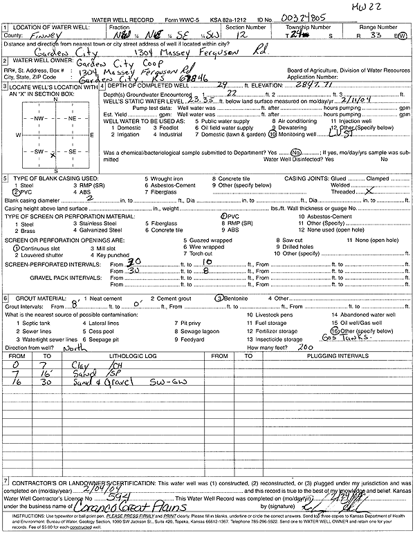
Specific Water Well Detail |
|
|
| Location Info | |||
| Owner: Garden City Coop, Inc. | Status: Constructed | ||
| Location: T24S, R33W, Sec. 12, NW NE SE SW | County: Finney | ||
| Directions: 1304 Massey Ferguson Rd, Garden City | |||
| Latitude: 37.977694 | Longitude: -100.8932962 | Datum NAD 27 | |
| Latitude: 37.9777172 | Longitude: -100.8937366 | Datum NAD 83 | |
| Longitude and latitude calculated by Survey from township-range-section-quarter calls. Only good to within the quarter call accuracy. | |||
| View well on interactive map | |||
| General Info | ||
| Well Depth: 29 ft. | Elevation: 2847.71 ft. | |
| Static Water Level: 23.35 ft. | Est. Yield: gpm. | |
| Comp. Date: 04-Feb-2004 | Well Use: Monitoring well/observation/piezometer | |
| DWR Applic. #: | Other ID: MW 22 | |
| Driller Info | ||
| Driller: Coranco Great Plains, Inc. | License #: 594 | |
| Scanned Form | View scan |
|
Chemical Sample Submitted?:
Water Well disinfected?: | ||
| Casing Info | ||
| Casing Type:
Casing Joints: |
Diam: in. to ft | |
| Casing height above land surface: in
Casing Weight: lbs/ft Wall thickness or gauge no.: | ||
| Screen and Perforation Info | ||
| Screen Type: | Screen Openings: | |
| Screen-perforated intervals | From: ft to ft | |
| Gravel pack intervals | From: ft to ft | |
| Grout Info | ||
| Grout used: | From: to ft | |
| Source of Possible Contamination | ||
| Source: | ||
| Direction from well: | Distance: ft | |
| Lithologic Log
(Log data entered by KGS.) | ||
| From: 0 ft. to 7 ft. | clay /CH | |
| From: 7 ft. to 16 ft. | sand /SP | |
| From: 16 ft. to 30 ft. | sand and gravel SW-GW | |